Frankclay, Missouri
From Wikipedia, the free encyclopedia
Frankclay, Missouri | |
|---|---|
 Frankclay, Missouri | |
| Coordinates: 37°51′47″N 90°36′52″W / 37.86306°N 90.61444°W | |
| Country | United States |
| State | Missouri |
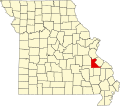
| County | St. Francois County |
| Area | |
• Total | 0.63 sq mi (1.64 km2) |
| • Land | 0.63 sq mi (1.64 km2) |
| • Water | 0 sq mi (0.00 km2) |
| Elevation | 886 ft (270 m) |
| Population (2020) | |
• Total | 194 |
| • Density | 307/sq mi (118.5/km2) |
| ZIP code | 63601[3] |
| Area code | 573 |
| FIPS code | 29-25516 |
| GNIS feature ID | 2587070[2] |
Frankclay is an unincorporated community and census-designated place in West Central St. Francois County, Missouri, United States.[2] It is located approximately one mile south of Route 8 about five miles west of Flat River. As of the 2020 census, Frankclay had a population of 194.[4]
A post office called Frankclay was established in 1905, and remained in operation until 1973.[5] The community has the name of the original owner of the town site.[6]