Frohnleiten
From Wikipedia, the free encyclopedia
Frohnleiten | |
|---|---|
 Southeast view of Frohnleiten | |
 Coat of arms | |
 Location within Graz-Umgebung district | |
 Frohnleiten Location within Austria | |
| Coordinates: 47°16′13″N 15°19′28″E / 47.27028°N 15.32444°E | |
| Country | Austria |
| State | Styria |
| District | Graz-Umgebung |
| Government | |
| • Mayor | Fabian Lackner (ÖVP) |
| Area | |
• Total | 153.91 km2 (59.42 sq mi) |
| Elevation | 438 m (1,437 ft) |
| Population (2018-01-01)[2] | |
• Total | 6,655 |
| • Density | 43.24/km2 (112.0/sq mi) |
| Time zone | UTC+1 (CET) |
| • Summer (DST) | UTC+2 (CEST) |
| Postal code | 8130 |
| Area code | 03126 |
| Vehicle registration | GU |
| Website | www.frohnleiten.org |
Frohnleiten (German: [fʁonˈlaɪ̯tn̩]) is a town in the district of Graz-Umgebung in the Austrian state of Styria.
 Town Hall of Frohnleiten
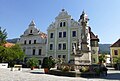 Baroque gables at the main square of Frohnleiten
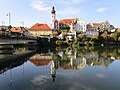 View of the old town center from a bridge over the river Mur


| Year | Pop. | ±% |
|---|---|---|
| 1869 | 3,843 | — |
| 1880 | 4,161 | +8.3% |
| 1890 | 4,457 | +7.1% |
| 1900 | 4,700 | +5.5% |
| 1910 | 5,117 | +8.9% |
| 1923 | 5,253 | +2.7% |
| 1934 | 5,936 | +13.0% |
| 1939 | 5,827 | −1.8% |
| 1951 | 6,718 | +15.3% |
| 1961 | 6,978 | +3.9% |
| 1971 | 7,056 | +1.1% |
| 1981 | 6,774 | −4.0% |
| 1991 | 6,841 | +1.0% |
| 2001 | 6,592 | −3.6% |
| 2011 | 6,062 | −8.0% |


