Fukuoka–Kitakyushu
Metropolitan area in Japan
From Wikipedia, the free encyclopedia
Fukuoka-Kitakyushu Greater Metropolitan Region (福岡・北九州大都市圏, Fukuoka Kitakyūshū Daitoshiken) is the most common name given to the region comprising the metropolitan areas of the cities of Fukuoka and Kitakyushu in Fukuoka Prefecture, Japan and in between.[3] Alternate names are many, including Kitakyushu-Fukuoka Greater Metropolitan Region (北九州・福岡大都市圏),[4] Northern Part of Kyushu Greater Metropolitan Region (北部九州大都市圏)[5]


One reason for complications in naming is because the whole region itself was once referred to as "Kitakyushu", which had become ambiguous after the city merger in 1963 which created the city by the same name.
These cities may be referred to separately, but often are lumped together since they are close and lie in the same prefecture. Furthermore, their economic spheres, infrastructure, and transport links overlap. Note that the metro areas include the tip of Honshu island (Shimonoseki on Honshu is a significant suburb of Kitakyushu), as well as the northern part of Kyushu. The definition of Northern Kyushu is not a superset of Fukuoka–Kitakyushu; among the ways it differs: it generally does not include any cities on Honshu island.
Definition
The region consists of the following areas:
| Administrative division | Population |
|---|---|
| Fukuoka-Kurume-Saga within Greater Fukuoka (福岡都市圏) | 2,868,977 (Oct 2006)[6] |
| Greater Kitakyushu (北九州都市圏)/Kanmon Metropolitan Area (関門都市圏) including Shimonoseki (下関都市圏) | 2,400,000 (2005 Census)[7] |
| Iizuka region (飯塚都市圏) | 200,000 (2005 Census) |
| Ube region (宇部都市圏) | 270,000 (Nov 2006)[8] |
| Fukuoka–Kitakyushu | 5,738,977 |
- The Ube region may or may not be considered part of this region, depending on definition
- Note: The cities of Ōita, Sasebo, Kumamoto are never included as being part of Fukuoka–Kitakyushu, despite their relative proximity to Fukuoka and Kitakyushu, rather, they are part of Northern Kyūshū.
Trends
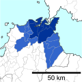
Fukuoka metropolitan area
Fukuoka MEA | |
|---|---|
 Fukuoka MEA as of 2015 | |
 Interactive map of Fukuoka metropolitan area | |
| Country | |
| Prefectures | |
| Core city | |
| Area (2011)[9] | |
• Total | 1,282.99 km2 (495.37 sq mi) |
| • Inhabitable area | 771.07 km2 (297.71 sq mi) |
| Population (2015)[10] | |
• Total | 2,565,501 |
| • Rank | 5th in Japan |
| • Density | 1,999.63/km2 (5,179.01/sq mi) |
| GDP (nominal)[9] | 8.92 trillion Japanese yen (2010) |
| Website | www |
There is a trend for concentration near Fukuoka, with the other areas declining in importance.
| Metropolitan area | 1980 | 1990 | 2000 | 2010 | 2015 |
|---|---|---|---|---|---|
| Fukuoka MEA | 1,773,129 | 2,129,424 | 2,329,021 | 2,495,552 | 2,565,501 |
| Kitakyushu MEA | 1,524,747 | 1,428,014 | 1,425,920 | 1,397,618 | 1,314,276 |
| Kurume MEA | 384,264 | 461,686 | 419,616 | 432,441 | 431,897 |
| Shimonoseki MEA | 348,875 | 338,049 | 287,935 | 280,947 | 268,517 |
| Iizuka McEA | 188,420 | 217,059 | 209,400 | 196,546 | 189,195 |
 Kitakyushu MEA as of 2010
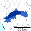 Kurume MEA as of 2010
 Shimonoseki MEA as of 2010
 Iizuka McEA as of 2010


