Galchutt, North Dakota
From Wikipedia, the free encyclopedia
Galchutt, North Dakota | |
|---|---|
 Looking north at Galchutt | |
 Galchutt, North Dakota  Galchutt, North Dakota | |
| Coordinates: 46°23′15″N 96°48′34″W / 46.38750°N 96.80944°W | |
| Country | United States |
| State | North Dakota |
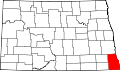
| County | Richland |
| Elevation | 951 ft (290 m) |
| Time zone | UTC-6 (Central (CST)) |
| • Summer (DST) | UTC-5 (CDT) |
| Area code | 701 |
| GNIS feature ID | 1029073[1] |
Galchutt is an unincorporated community in Richland County, North Dakota, United States. Galchutt is located along the Red River Valley and Western Railroad 12.9 miles (20.8 km), northwest of Wahpeton.[2]