Gamaliel, Arkansas
From Wikipedia, the free encyclopedia
Gamaliel, Arkansas | |
|---|---|
 Gamaliel, Arkansas  Gamaliel, Arkansas | |
| Coordinates: 36°27′07″N 92°14′13″W / 36.45194°N 92.23694°W[1] | |
| Country | United States |
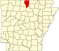
| State | Arkansas |
| County | Baxter |
| Elevation | 869 ft (265 m) |
| Population (2020) | |
• Total | 33 |
| Time zone | UTC-6 (Central (CST)) |
| • Summer (DST) | UTC-5 (CDT) |
| ZIP code | 72537 |
| Area code | 870 |
| GNIS feature ID | 2805646[1] |
Gamaliel /ɡəˈmeɪl.iːə/ gə-MAIL-ee-ə is an unincorporated community and census-designated place (CDP) in Baxter County, Arkansas, United States. Gamaliel is located along Arkansas Highway 101, 12 miles (19 km) northeast of Mountain Home and 3 mi (4.8 km) south of the Arkansas—Missouri border. Gamaliel has a post office with ZIP code 72537.[2]
Gamaliel is located on a ridge between Bennetts Bayou to the east and the Norfork River/Norfork Lake to the west. Gamaliel campground on the east arm of Norfork Lake is about three miles to the southeast.[3]
It was first listed as a CDP in the 2020 census with a population of 33.[4]