Garnwerd
Village in Groningen, Netherlands
From Wikipedia, the free encyclopedia
Garnwerd is a wierde village next to the Reitdiep in the municipality of Westerkwartier in the Dutch province of Groningen.

Garnwerd | |
|---|---|
The church and windmill of Garnwerd | |
 Garnwerd Location of Garnwerd in Groningen in the Netherlands  Garnwerd Garnwerd (Netherlands) | |
| Coordinates: 53°18′16″N 6°29′34″E | |
| Country | |
| Province | |
| Municipality | |
| Area | |
• Total | 0.20 km2 (0.077 sq mi) |
| Elevation | 0.9 m (3.0 ft) |
| Population (2021)[1] | |
• Total | 340 |
| • Density | 1,700/km2 (4,400/sq mi) |
| Time zone | UTC+1 (CET) |
| • Summer (DST) | UTC+2 (CEST) |
| Postal code | 9893[1] |
| Dialing code | 0594 |
History
The village was first mentioned in the 10th or 11th century as "ad Granauurð". The etymology is unclear.[3] Garnwerd is an elongated terp (artificial living hill) village which developed in the Middle Ages. In 1629, the Reitdiep was canalised and moved to the village. The village flourished due to the trade from Groningen to the former Lauwerszee.[4]
The choir of the Dutch Reformed church dates from 1229. In 1738, the tower collapsed and was rebuilt in 1751.[4] The grist mill De Meeuw dates from 1851, and is occasionally used to grind grain.[5]
Garnwerd was home to 465 people in 1840.[6] In 1876, the Eems Canal was dug and development of the village stagnated.[4] Garnwerd was part of the municipality of Ezinge. In 1990, it became part of Winsum. In 2019, it became part of the municipality of Westerkwartier
Gallery
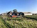 Barn construction in Garnwerd
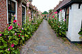 Alley in Garnwerd
 Children's playground
 Harbour of Garnwerd


