Garrafrauns
From Wikipedia, the free encyclopedia
Garrafrauns
Na Garfráin | |
|---|---|
Village | |
 Garrafrauns village, along R328 road | |
 Garrafrauns Location in Ireland | |
| Coordinates: 53°38′01″N 8°49′30″W / 53.633611°N 8.825°W | |
| Country | Ireland |
| Province | Connacht |
| County | County Galway |
| Government | |
| • Dáil Éireann | Galway East |
| • EU Parliament | Midlands–North-West |
| Time zone | UTC+0 (WET) |
| • Summer (DST) | UTC-1 (IST (WEST)) |
| Area code | +353 93 |
| Irish Grid Reference | M451652 |
| Website | garrafrauns |
Garrafrauns (Irish: Na Garfráin)[1] is a village and 202 acre townland[2] in north County Galway, Ireland. The name Garrafrauns is derived from either Garra bhfearán (garden of the wild brambles) or Garbhthráin (rough grassy place).[3] The village consists of a church, school, garage and a multiple-use community centre. Garrafrauns is four miles from Dunmore along the R328 road. Other neighbouring towns and villages are Cloonfad (5 miles), Irishtown (3 miles), Milltown (5 miles), and Tuam (9 miles).
A sandstone, cruciform, gothic design church with a thatched roof and whitewashed interior was built in Garrafrauns village in 1820. A replacement church situated across the road from this original, was completed in 1913 and consecrated by Archbishop Gilmartin of Tuam. The bell tower has since been removed. Garrafrauns lies in the middle of a half parish of Dunmore, and the parish comprises 16 townlands.[4]
 Exterior view of old church
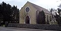 Exterior view of St. Patrick's Church
 Altar and window
 Statue in grounds


Garrafrauns National School
Garrafrauns National School was opened in 1975, with the school increased in size in 1985 with amalgamation with nearby Strawberry Hill National School. Originally built as a three-room school, it has now been extended and has a large mixed use play area to the front. The school has developed a vegetable garden for which the pupils are responsible.[5] The school participates in the Green School Project, which is intended to raise awareness of environmental issues.[6]
