Gebsattel
Municipality in Bavaria, Germany
From Wikipedia, the free encyclopedia
Gebsattel is a municipality in the district of Ansbach in Bavaria in Germany. It lies on the Tauber River.

Gebsattel | |
|---|---|
Gebsattel Castle | |
 Coat of arms | |
Location of Gebsattel
within Ansbach district 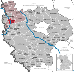 | |
 Location of Gebsattel | |
 Gebsattel  Gebsattel | |
| Coordinates: 49°21′N 10°11′E | |
| Country | Germany |
| State | Bavaria |
| Admin. region | Mittelfranken |
| District | Ansbach |
| Municipal assoc. | Rothenburg ob der Tauber |
| Subdivisions | 3 Ortsteile |
| Government | |
| • Mayor (2020–26) | Gerd Rößler[1] |
| Area | |
• Total | 19.12 km2 (7.38 sq mi) |
| Elevation | 378 m (1,240 ft) |
| Population (2024-12-31)[2] | |
• Total | 1,738 |
| • Density | 90.90/km2 (235.4/sq mi) |
| Time zone | UTC+01:00 (CET) |
| • Summer (DST) | UTC+02:00 (CEST) |
| Postal codes | 91607 |
| Dialling codes | 09861 |
| Vehicle registration | AN |
| Website | www.gebsattel.de |
Main sights
 Catholic church of Saint Laurentius
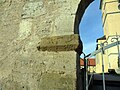 One of the old gates

-26032012.JPG)
Neighborhoods, districts
Gebsattel has nine neighborhoods or districts:[3]
- Bockenfeld
- Eckartshof
- Gebsattel
- Kirnberg
- Pleikartshof
- Rödersdorf
- Speierhof
- Wasenmühle
- Wildenhof