Georgetown (CDP), Maryland
From Wikipedia, the free encyclopedia
Georgetown, Maryland | |
|---|---|
 Georgetown  Georgetown | |
| Coordinates: 39°13′16″N 76°11′47″W / 39.22111°N 76.19639°W | |
| Country | |
| State | |
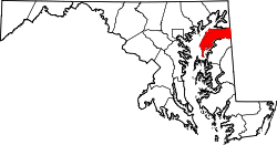
| County | |
| Area | |
• Total | 1.47 sq mi (3.82 km2) |
| • Land | 1.47 sq mi (3.81 km2) |
| • Water | 0.0039 sq mi (0.01 km2) |
| Elevation | 43 ft (13 m) |
| Population (2020) | |
• Total | 117 |
| • Density | 79.6/sq mi (30.73/km2) |
| Time zone | UTC-5 (Eastern (EST)) |
| • Summer (DST) | UTC-4 (EDT) |
| Area codes | 410 & 443 |
| FIPS code | 24-31875 |
| GNIS feature ID | 2583629[2] |
Georgetown is an unincorporated community and census-designated place in western Kent County, Maryland, United States.[2] Per the 2020 census, the population was 117.[3] It should not be confused with the community of the same name 22 miles (35 km) to the northeast on the Kent/Cecil County border.