Getelo
From Wikipedia, the free encyclopedia
Getelo | |
|---|---|
 Coat of arms | |
Location of Getelo within Grafschaft Bentheim district 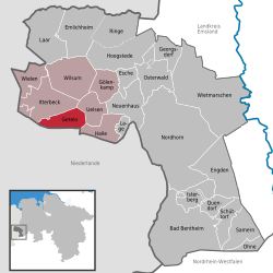 | |
 Getelo  Getelo | |
| Coordinates: 52°28′00″N 06°50′59″E / 52.46667°N 6.84972°E | |
| Country | Germany |
| State | Lower Saxony |
| District | Grafschaft Bentheim |
| Municipal assoc. | Uelsen |
| Subdivisions | 2 centres |
| Government | |
| • Mayor | Jan-Hindrik Schipper |
| Area | |
• Total | 20.24 km2 (7.81 sq mi) |
| Elevation | 68 m (223 ft) |
| Population (2022-12-31)[1] | |
• Total | 525 |
| • Density | 26/km2 (67/sq mi) |
| Time zone | UTC+01:00 (CET) |
| • Summer (DST) | UTC+02:00 (CEST) |
| Postal codes | 49843 |
| Dialling codes | 0 59 42 |
| Vehicle registration | NOH |
| Website | www.uelsen.de |
Getelo is a community in the district of Grafschaft Bentheim in Lower Saxony.
Location
Getelo lies west of Nordhorn on the border with the Netherlands. It belongs to the Joint Community (Samtgemeinde) of Uelsen, whose administrative seat is in the like-named community.
Constituent communities
The community’s two centres are Getelo and Getelomoor.
Politics
Mayor
The honorary mayor Jan-Hindrik Schipper was elected on 9 September 2001.
Culture and sightseeing
Buildings
Söven Pölle, barrows from the Bronze Age, are found in the community. The name gives the number as seven, although there were once as many as 26.
