Glacier Peak (Bow Range)
Mountain in Alberta and British Columbia, Canada
From Wikipedia, the free encyclopedia
Glacier Peak is a mountain in Banff National Park and straddles the Continental Divide marking the Alberta-British Columbia border. It is situated between Mount Lefroy and Ringrose Peak in the Bow Range of the Canadian Rockies.[3] It was named in 1894 by Samuel E.S. Allen in reference to the glacier on the northern side of the mountain.[4][1]

| Glacier Peak | |
|---|---|
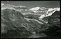
Glacier Peak (centered) with Mount Lefroy in upper left and Ringrose Peak in upper right as seen from Lake Oesa | |
| Highest point | |
| Elevation | 3,302 m (10,833 ft)[1] |
| Prominence | 72 m (236 ft)[1] |
| Listing | |
| Coordinates | 51°21′03″N 116°17′04″W[2] |
| Geography | |
 Glacier Peak Location in Alberta  Glacier Peak Location in British Columbia  Glacier Peak Location in Canada | |
| Country | Canada |
| Provinces | Alberta and British Columbia |
| Protected area | Banff National Park[3] |
| Parent range | Bow Range[3] |
| Topo map | NTS 82N8 Lake Louise |
| Climbing | |
| First ascent | 1909 V. Fynn; A. Hart; C. Richardson; L. Wilson[4] |
Geology
Glacier Peak is composed of sedimentary rock laid down during the Precambrian to Jurassic periods.[5] Formed in shallow seas, this sedimentary rock was pushed east and over the top of younger rock during the Laramide orogeny.[6]
Climate
Based on the Köppen climate classification, Glacier Peak is located in a subarctic climate zone with cold, snowy winters, and mild summers.[7] Temperatures can drop below −20 °C with wind chill factors below −30 °C.
Gallery
 Glacier Peak in upper right corner
 Glacier Peak, north aspect
_BHL48165239.jpg)
