Glen Elder Township, Mitchell County, Kansas
From Wikipedia, the free encyclopedia
Glen Elder Township | |
|---|---|
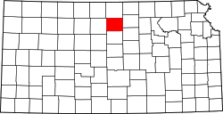
 Location within Mitchell County | |
| Coordinates: 39°31′26″N 98°19′14″W / 39.5238803°N 98.3205005°W, 39°29′23″N 98°22′33″W / 39.4898089°N 98.3758196°W, 39°31′58″N 98°22′33″W / 39.5327096°N 98.3758789°W, 39°29′25″N 98°19′11″W / 39.4901807°N 98.3197321°W[1] | |
| Country | United States |
| State | Kansas |
| County | Mitchell |
| Area | |
• Total | 36.057 sq mi (93.39 km2) |
| • Land | 30.352 sq mi (78.61 km2) |
| • Water | 5.705 sq mi (14.78 km2) 15.82% |
| Elevation | 1,470 ft (448 m) |
| Population (2020) | |
• Total | 432 |
| • Density | 14.2/sq mi (5.50/km2) |
| Time zone | UTC-6 (CST) |
| • Summer (DST) | UTC-5 (CDT) |
| Area code | 785 |
Glen Elder Township is a township in Mitchell County, Kansas, United States.
Communities
Glen Elder Township covers an area of 36.057 square miles (93.39 square kilometers). The Solomon River flows through it, and parts of Waconda Lake lie within the township.
Adjacent townships
- Athens Township, Jewell County (north)
- Browns Creek Township, Jewell County (northeast)
- Solomon Rapids Township, Mitchell County (east)
- Turkey Creek Township, Mitchell County (southeast)
- Walnut Creek Township, Mitchell County (south)
- Carr Creek Township, Mitchell County (southwest)
- Cawker Township, Mitchell County (west)