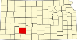
Grandview Township, Ford County, Kansas
From Wikipedia, the free encyclopedia
Grandview Township | |
|---|---|
 Location in Ford County | |
| Coordinates: 37°49′33″N 099°56′45″W / 37.82583°N 99.94583°W | |
| Country | United States |
| State | Kansas |
| County | Ford |
| Area | |
• Total | 87.43 sq mi (226.45 km2) |
| • Land | 87.26 sq mi (226.01 km2) |
| • Water | 0.17 sq mi (0.44 km2) 0.19% |
| Elevation | 2,516 ft (767 m) |
| Population (2020) | |
• Total | 569 |
| • Density | 6.52/sq mi (2.52/km2) |
| GNIS feature ID | 0471631 |
Grandview Township is a township in Ford County, Kansas, United States. As of the 2020 census, its population was 569.
Grandview Township covers an area of 87.43 square miles (226.4 km2) and contains no incorporated settlements. According to the USGS, it contains one cemetery, Pleasant Vale.
The streams of Duck Creek, Elm Creek and South Fork Duck Creek run through this township.
Communities
It contains the census-designated place of Fort Dodge.
Transportation
Grandview Township contains one airport or landing strip, Wilroads Gardens Airport.