Hale, Iowa
From Wikipedia, the free encyclopedia
Hale, Iowa | |
|---|---|
 Hale  Hale | |
| Coordinates: 42°00′45″N 91°03′34″W / 42.01250°N 91.05944°W | |
| Country | United States |
| State | Iowa |
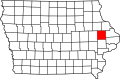
| County | Jones |
| Elevation | 797 ft (243 m) |
| Time zone | UTC-6 (Central (CST)) |
| • Summer (DST) | UTC-5 (CDT) |
| Area code | 319 |
| GNIS feature ID | 457200[1] |
Hale (also known as Hale Village) is an unincorporated community in Jones County, Iowa, United States. Hale is north of the Wapsipinicon River, east of Olin, and west of Oxford Junction.