Harpersfield Covered Bridge
Covered bridge in Ohio, United States
From Wikipedia, the free encyclopedia
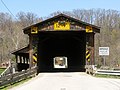
Harpersfield Bridge is a covered bridge spanning the Grand River in Harpersfield Township, Ashtabula County, Ohio, United States. This double-span Howe truss bridge, one of currently 17 drivable covered bridges in the county, is the third longest covered bridge in Ohio at 228 feet. A flood in 1913 washed away the land at the north end of the bridge, and the steel span was subsequently attached. The bridge features a walkway, added during its renovation in 1991–1992. The bridge also features an Ashtabula County MetroPark at its north end and is listed on the National Register of Historic Places.[2][3] The bridge's WGCB number is 35-04-19,[4] and it is located approximately 3.4 miles (5.5 kilometres) south of Geneva.
_Covered_Bridge_1.jpg)
Harpersfield Covered Bridge | |
| |
   | |
| Location | County Road 154 over the Grand River, Harpersfield, Ohio |
|---|---|
| Coordinates | 41°45′22″N 80°56′40″W |
| Area | less than one acre |
| Built | 1873 |
| Built by | Potter |
| Architectural style | Howe truss covered bridge |
| NRHP reference No. | 75001315[1] |
| Added to NRHP | November 3, 1975 |
| Coordinates | 41°45′21″N 80°56′39″W |
| Locale | Ashtabula County |
| Characteristics | |
| Design | Double span, Howe truss |
| Total length | 228 feet (69.5 m) |
| History | |
| Construction start | 1868 |
| Location | |
 Interactive map of Harpersfield Bridge | |
History
- 1868[3] or 1873[2] – Bridge constructed
- 1913 – Northern part of land washed out, steel span added[3]
- 1962 – Bypassed when State Route 534 was rerouted around the settlement of Harpersfield[5][6]
- 1975 - Added to National Register of Historic Places
- 1991–1992[3] and 2022–2024[7][8] – Bridge renovated
Dimensions
- Length: 228 feet (69 m)
- Overhead clearance: 12 feet 9 inches (3.89 m)
Gallery
 A panoramic view of the bridge in June 2016.




 Ohio Historical Marker
 A panoramic view of Grand River in June 2016.


.jpg)


.jpg)
.jpg)


