Hermeskeil
From Wikipedia, the free encyclopedia
Hermeskeil | |
|---|---|
 | |
 Coat of arms | |
Location of Hermeskeil
within Trier-Saarburg district 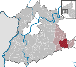 | |
 Location of Hermeskeil | |
 Hermeskeil  Hermeskeil | |
| Coordinates: 49°39′26″N 6°56′56″E / 49.65722°N 6.94889°E | |
| Country | Germany |
| State | Rhineland-Palatinate |
| District | Trier-Saarburg |
| Municipal assoc. | Hermeskeil |
| Subdivisions | 3 |
| Government | |
| • Mayor (2019–24) | Lena Weber[1] (SPD) |
| Area | |
• Total | 30.89 km2 (11.93 sq mi) |
| Elevation | 540 m (1,770 ft) |
| Population (2024-12-31)[2] | |
• Total | 7,511 |
| • Density | 243.2/km2 (629.8/sq mi) |
| Time zone | UTC+01:00 (CET) |
| • Summer (DST) | UTC+02:00 (CEST) |
| Postal codes | 54411 |
| Dialling codes | 06503 |
| Vehicle registration | TR |
| Website | www.hermeskeil.de |
Hermeskeil (German pronunciation: [ˈhɛʁməskaɪl] ⓘ) is a town in the Trier-Saarburg district, in Rhineland-Palatinate, Germany. It is situated in the Hunsrück, approx. 25 km southeast of Trier. Its population is about 5,900.
Hermeskeil is the seat of the Verbandsgemeinde ("collective municipality") Hermeskeil.
The old locomotive depot, Bahnbetriebswerk Hermeskeil is now a museum housing German steam engines.
The Flugausstellung aircraft museum displays more than 100 aircraft and is the largest private museum of that kind in Europe.
A Gaulish burial of the 1st century AD was discovered in a field near Hermeskeil in 2009.[3]
A Roman castrum has been identified in 2015: it is the only castrum created by Julius Caesar inside Magna Germania, when he crossed the Rhine river in 53 BC[4]
Notable people
- Bettina Brück (born 1967), German politician
- Shida Bazyar (born 1988), German writer
