Holten
From Wikipedia, the free encyclopedia
Holten | |
|---|---|
Town | |
.jpg) Church | |
 Flag  Coat of arms | |
 Holten Location in the province of Overijssel in the Netherlands  Holten Holten (Netherlands) | |
| Coordinates: 52°16′53″N 6°25′07″E / 52.28139°N 6.41861°E | |
| Country | |
| Province | Overijssel |
| Municipality | Rijssen-Holten |
| Area | |
• Total | 5.16 km2 (1.99 sq mi) |
| Elevation | 20 m (66 ft) |
| Population (2021)[1] | |
• Total | 9,410 |
| • Density | 1,820/km2 (4,720/sq mi) |
| Time zone | UTC+1 (CET) |
| • Summer (DST) | UTC+2 (CEST) |
| Postal code | 7451[1] |
| Dialing code | 0548 |
| Website | www |
Holten (Dutch Low Saxon: Hooltn) is a village in the municipality of Rijssen-Holten in the Dutch province of Overijssel. Holten is located in a forested area just south of the Holterberg, a 65-metre (210 ft) hill, and is part of the Sallandse Heuvelrug National Park. The National Park is the only area in the Netherlands in which the black grouse (in Dutch: korhoen) can be found. This grouse population is on the brink of extinction, so parts of the National Park are closed to the public during its breeding season.
Holten Canadian War Cemetery[3] is the second-largest World War II cemetery in the Netherlands and is administered by the Commonwealth War Graves Commission. It is located in a forested area 3 kilometres (1.9 mi) north-east of Holten railroad station, and is accessible by car or bicycle via a number of sand roads. Canadian Prime Minister Stephen Harper visited the cemetery on May 4, 2015, in commemoration of the 70th anniversary of Victory in Europe Day.[4]
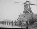 Canadian troops move through Holten, April 1945
 Canadian cemetery in Holterberg

