Hotham Heights
Geological feature in the Falkland Islands
From Wikipedia, the free encyclopedia
Hotham Heights occupy the western interior of Weddell Island in the Falkland Islands.[1] The feature extends 9 km (5.6 mi) in southwest–northeast direction and 6 km (3.7 mi) in southeast–northwest direction, rising to 236 m (774 ft) at Chatham Hill. Hotham Heights are centred at 51°52′10″S 61°04′30″W.


Maps
- The Falkland Islands. Scale 1:401280 map. London: Edward Stanford, 1901
- Falkland Islands Explorer Map. Scale 1:365000. Ocean Explorer Maps, 2007
- Falklands Topographic Map Series. Scale 1:50000, 29 sheets. DOS 453, 1961-1979
- Falkland Islands. Scale 1:643000 Map. DOS 906. Edition 3-OS, 1998
- Map 500k--xm20-4. 1:500000 map of Weddell Island and part of West Falkland. Russian Army Maps (for the world)
- Approaches to the Falkland Islands. Scale 1:1500000 chart. Gps Nautical Charts, 2010
- Illustrated Map of Weddell Island
Gallery
 Old map of Weddell Island featuring Chatham Harbour
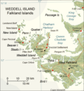 Map of Weddell Island

