Hoyt, Oklahoma
From Wikipedia, the free encyclopedia
Hoyt, Oklahoma | |
|---|---|
 Hoyt  Hoyt | |
| Coordinates: 35°16′05″N 95°18′01″W / 35.26806°N 95.30028°W | |
| Country | United States |
| State | Oklahoma |
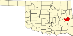
| County | Haskell |
| Area | |
• Total | 0.97 sq mi (2.52 km2) |
| • Land | 0.97 sq mi (2.52 km2) |
| • Water | 0.0039 sq mi (0.01 km2) |
| Elevation | 568 ft (173 m) |
| Population (2020) | |
• Total | 82 |
| • Density | 84/sq mi (32.6/km2) |
| Time zone | UTC-6 (Central (CST)) |
| • Summer (DST) | UTC-5 (CDT) |
| ZIP code | 74440 |
| Area codes | 918 & 539 |
| GNIS feature ID | 2629922[2] |
Hoyt is an unincorporated community and census-designated place (CDP) in Haskell County, Oklahoma, United States.[2] The community is 3.9 miles (6.3 km) west-northwest of Whitefield. A post office was established at Hoyt, Indian Territory on August 19, 1890. It was named for Babe Hoyt, a local ferryboat operator.[3] The post office closed on April 17, 2004; it still has its own ZIP code, 74440.[4][5]
As of the 2020 census, Hoyt had a population of 82.[6]
It is home to the Hoyt School, which is no longer in use, but has been nominated for classification as an official Oklahoma landmark.[7]
At the time of its founding, Hoyt was located in the Moshulatubbee District of the Choctaw Nation.[8]