Illizi
City in Illizi Province, Algeria
From Wikipedia, the free encyclopedia
Illizi (Amazigh language: Ilizi) is an Algerian town and commune, coextensive with Illizi District,[2] situated in the south-eastern part of Algeria, and capital of Illizi Province. According to the 2008 census it is the largest commune by population in the province, with a population of 17,252,[1] up from 10,163 in 1998,[3] and an annual population growth rate of 5.5%, the highest in the province.[1] It is one of the gates to the Tassili N'Ajjer National Park with caves and partly enclosed rock shelters containing prehistoric drawings dating from 6000 years BC. There are a hotel and two camping sites, as well as many local tourist agencies. During French colonial rule, the town was called Fort Polignac (1909–1962).
 Public Services Directorate of Illizi
 Ibn Badis School Illizi
 Street scene in a residential area, Illizi
 Boutique in Illizi
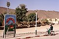 Illizi. The text's translation: "I love Nature, therefore I protect it".
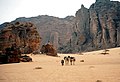 Natural areas in the nearby Tassili n'Ajjer Mountains


Illizi
إيليزي | |
|---|---|
 General aspect of Illizi central quarter | |
 Location of Illizi Commune within Illizi Province | |
 Illizi Location of Illizi within Algeria | |
| Coordinates: 26°30′18″N 8°28′56″E | |
| Country | |
| Province | Illizi Province |
| District | Illizi District |
| Government | |
| • PMA Seats | 11 |
| Area | |
• Total | 75,945 km2 (29,323 sq mi) |
| Elevation | 567 m (1,860 ft) |
| Population (2008)[1] | |
• Total | 17,252 |
| • Density | 0.22716/km2 (0.58835/sq mi) |
| Time zone | UTC+01 (CET) |
| Postal code | 37000 |
| ONS code | 3301 |
Climate
Illizi has a hot desert climate (Köppen climate classification BWh), with long, extremely hot summers and short, very warm winters. The town is virtually rainless throughout the year as the average annual rainfall is around 10 mm (0.39 in), and summers are especially dry. The sky is always clear over Illizi all year long and the relative humidity is very low.
| Climate data for Illizi (1991–2020) | |||||||||||||
|---|---|---|---|---|---|---|---|---|---|---|---|---|---|
| Month | Jan | Feb | Mar | Apr | May | Jun | Jul | Aug | Sep | Oct | Nov | Dec | Year |
| Record high °C (°F) | 35.0 (95.0) |
38.5 (101.3) |
40.5 (104.9) |
44.7 (112.5) |
45.3 (113.5) |
47.7 (117.9) |
47.6 (117.7) |
46.7 (116.1) |
45.7 (114.3) |
42.0 (107.6) |
38.2 (100.8) |
33.5 (92.3) |
47.7 (117.9) |
| Mean daily maximum °C (°F) | 20.6 (69.1) |
23.4 (74.1) |
28.3 (82.9) |
33.7 (92.7) |
37.8 (100.0) |
41.4 (106.5) |
42.1 (107.8) |
41.4 (106.5) |
39.5 (103.1) |
34.0 (93.2) |
27.2 (81.0) |
21.8 (71.2) |
32.6 (90.7) |
| Daily mean °C (°F) | 12.6 (54.7) |
15.3 (59.5) |
20.1 (68.2) |
25.4 (77.7) |
30.2 (86.4) |
33.6 (92.5) |
33.9 (93.0) |
33.5 (92.3) |
31.7 (89.1) |
26.3 (79.3) |
19.4 (66.9) |
14.2 (57.6) |
24.7 (76.5) |
| Mean daily minimum °C (°F) | 4.7 (40.5) |
7.2 (45.0) |
11.9 (53.4) |
17.1 (62.8) |
22.4 (72.3) |
25.7 (78.3) |
25.8 (78.4) |
25.6 (78.1) |
23.9 (75.0) |
18.6 (65.5) |
11.6 (52.9) |
6.6 (43.9) |
16.8 (62.2) |
| Record low °C (°F) | −4.0 (24.8) |
−1.9 (28.6) |
0.7 (33.3) |
5.6 (42.1) |
9.1 (48.4) |
17.5 (63.5) |
19.3 (66.7) |
19.0 (66.2) |
15.4 (59.7) |
9.5 (49.1) |
1.7 (35.1) |
−2.2 (28.0) |
−4.0 (24.8) |
| Average precipitation mm (inches) | 1.8 (0.07) |
2.2 (0.09) |
2.2 (0.09) |
1.4 (0.06) |
1.5 (0.06) |
2.0 (0.08) |
0.0 (0.0) |
0.5 (0.02) |
1.8 (0.07) |
2.5 (0.10) |
1.8 (0.07) |
1.7 (0.07) |
19.4 (0.76) |
| Average precipitation days (≥ 1.0 mm) | 0.3 | 0.3 | 0.3 | 0.4 | 0.4 | 0.5 | 0 | 0.1 | 0.5 | 0.6 | 0.3 | 0.4 | 4.1 |
| Average relative humidity (%) | 48 | 39 | 33 | 30 | 27 | 27 | 24 | 22 | 25 | 32 | 43 | 42 | 33 |
| Source 1: NOAA[4] | |||||||||||||
| Source 2: Weatherbase (humidity)[5] | |||||||||||||
Transport
Economy
Education
Sports
The city is home to CSSW Illizi, an amateur side which plays in the south-east group of the Inter-Régions Division, the third tier of the Algerian football pyramid.
Localities
History
In July 1903, the French captain Pein came to the Oued Ilezi with a troop and determined that it was an ideal place for a military base: a good waterhole with water at a depth of 50–100 cm, a raised area next to it with a very good defensive position and plenty of pastures and wood in the surrounding area.
In May 1908, Colonel Laperrine, commander of the French Sahara troops, came to the Oued Ilezi and determined the exact location of the planned Polignac fort on a small rocky plateau, a few meters above the course of the river. Construction of the fort then began. It was completed in September 1909.
In the same year, after its completion, the French captain Niéger visited the Kel Iherir-Tuareg in the Oued Iherir, 120 km south of Illizi. He promised the ethnic group that wells would be drilled in the Oued Ilezi the following winter and that their ethnic group would be granted water and land rights there. This is how people from the Kel Iherir became the first inhabitants of the village of Fort Polignac.[10] - In 1957, Fort Polignac had around 1000 inhabitants.[11]
 Illizi 1991: Residental quarter
 Illizi 1991: Small Mosque on the outskirts
 Illizi 1991: Street scene downtown


