Itanagar
State capital city in Arunachal Pradesh, India
From Wikipedia, the free encyclopedia
Itanagar (/iːˈtɑːnəɡər/ⓘ) is the capital and largest town of the Indian state of Arunachal Pradesh. The seat of Arunachal Pradesh Legislative Assembly, the seat of government of Arunachal Pradesh, and the seat of Gauhati High Court permanent bench at Naharlagun are all in Itanagar. Being the hub of all the major economic bases, Itanagar, along with the adjacent town of Naharlagun, comprises the administrative region of the Itanagar Capital Complex Region. This stretches from the Itanagar Municipal limit at Chandranagar Town, until Nirjuli Town, and is a major hub of cultural, economic, fashion, education and recreational activities.

Itanagar | |
|---|---|
From top, left to right: Donyi Polo Airport, Ganga/Gyakar Sinyi lake, Lake at Itanagar, Ita Fort southern gate, Shatabdi Express from Itanagar station to Guwahati, Jawaharlal Nehru Museum, Itanagar, Rajiv Gandhi University | |
| Nickname: Capital of Arunachal | |
  Itanagar Location of Itanagar in Arunachal Pradesh  Itanagar Itanagar (India) | |
| Coordinates: 27°06′00″N 93°37′12″E | |
| Country |  India India |
| State | Arunachal Pradesh |
| District | Itanagar |
| Government | |
| • Type | Municipal Corporation |
| • Body | Itanagar Municipal Corporation |
| • Mayor | Likha Nari Tadar (BJP)[1] |
| • Deputy Mayor | Tok Tabin Camdir (BJP)[1] |
| • Lok Sabha MP | Kiren Rijiju (BJP) |
| • MLA | Techi Kaso (BJP) |
| Area | |
• Total | 51.69 km2 (19.96 sq mi) |
| Elevation | 320 m (1,050 ft) |
| Population (2011) | |
• Total | 59,490 |
| • Density | 1,151/km2 (2,981/sq mi) |
| Demonym | Itanagari |
| Languages | |
| • Official | English |
| Time zone | UTC+5:30 (IST) |
| PINs | 791111, 791112, 791113 |
| Vehicle registration | AR-01, AR-02 |
| Sex ratio | 1.05 (♂/♀) |
| Literacy rate | 85.17% |
| Website | imc |


Etymology
Itanagar derives its name from Ita Fort, the 'fort of bricks' situated in the heart of Itanagar. The fort has an irregular shape, built mainly with bricks, dating back to the 14th-15th century of the Chutia kingdom.[2]
Demographics
As of 2011[update] India census,[3] Itanagar had a population of 59,490. Males constituted 53% of the population and females 47%. Itanagar has an average literacy rate of 66.95%, lower than the national average of 74.4%: male literacy is 73.69%, and female literacy is 59.57%. In Itanagar, 15% of the population is under 6 years of age.
Religion
A majority of the tribes are worshipers of nature, with Tani Tribes being descendants of the Forefather Abotani, being followers of Donyi-Polo. According to the 2011 census, 40.94% of the population is Hindu, 29.51% Christian, 21.17% Donyi Polo, 4.52% Muslim and 2.88% Buddhist.
Languages
According to 2011 census, Nishi was the most spoken language in Itanagar with 17,896 speakers, followed by Bengali at 8,125, Adi at 8,102, Apatani at 4,256, Nepali at 3,721, Hindi at 3,641, Assamese at 3,538 and Bhojpuri at 1,987.
Geography
Itanagar is located at 27.1°N 93.62°E in the southern foothills of the Eastern Himalayas. It has an average elevation of 320 m (1,050 ft). The city occupies an undulating landscape of forested hills and intervening valleys, with the terrain descending southwards towards the Brahmaputra Valley in neighbouring Assam.[6]

Itanagar forms part of the wider Itanagar Capital Complex, an administrative jurisdiction that also includes Naharlagun and Banderdewa.[7] The Capital Complex covers an area of approximately 200 km2 (77 sq mi).[8]
Around 6 km (3.7 mi) from the city centre is Gekar Sinyi, commonly called Ganga Lake. It is a naturally formed lake enclosed by hard-rock banks and surrounded by trees, ferns and orchids. Its Nyishi name is commonly translated as “confined water”.[9]
Culture
As the state capital, Itanagar is a multi-ethnic urban centre inhabited by communities from across Arunachal Pradesh. These include the Nyishi, Adi, Apatani, Galo and Tagin, among others. The city's diversity is also reflected in its languages: the 2011 census recorded Nyishi, Adi, Apatani, Bengali, Nepali, Hindi, Assamese and Bhojpuri among its widely spoken mother tongues.[10]
Festivals associated with the different communities of the state are publicly celebrated in the capital. These include Nyokum Yullo of the Nyishi, marked by communal rituals, traditional dances and feasting, and Losar, observed by the city's Buddhist communities.[11]
A major institution documenting the cultural heritage of Arunachal Pradesh is the Jawaharlal Nehru State Museum. Its collections include traditional textiles, weapons, household objects, handicrafts and archaeological material representing the state's different communities. The Craft Centre and Emporium displays local handloom products, traditional clothing, wall paintings and objects made from cane and bamboo.[9]
The Centre for Buddhist Culture, commonly known as the Gompa, is situated on a hill above the State Museum and serves as one of the city's principal Buddhist religious and cultural landmarks.[12]
Itanagar has a number of tribes, i.e., Nyishi, Adi, Apatani, Tagin, Galo, etc.
Education


Universities and colleges
- Dera Natung Government College
- Don Bosco College
- Himalayan University
- NERIST
- National Institute of Technology, Arunachal Pradesh
- Rajiv Gandhi Government Polytechnic
- Rajiv Gandhi University
- Tomo Riba Institute of Health and Medical Sciences
- Indira Gandhi National Open University[13]
Media and communications
Television
DD Arunprabha is the state-owned television broadcaster of Arunachal Pradesh.[14]
Radio
Radio stations of Itanagar are: All India Radio, RadioCity Itanagar (Arunachal Pradesh's first community radio) and Big FM 92.7 (India's largest national radio network).
Newspapers
- The Arunachal Times
- Echo of Arunachal
- Dawnlit Post
Places of Interest
- Ita Fort, one of the most important historical sites in the state of Arunachal Pradesh. The name literally means "Fort of bricks"( brick being called "Ita" in the Assamese language). The Ita Fort was built as early as the 14th or the 15th century. The fort is mainly built with bricks, forming an irregular shape. The total brickwork is of 16,200 cubic meters, which has been identified by some scholars with the Chutiya kingdom. The fort has three different entrances on three different sides, which are the western, eastern, and southern sides.
- Jawaharlal Nehru Museum, Itanagar is also known for showcasing the rich tribal culture of the state.
- Gekar sinyi (Ganga Lake) is a beautiful natural lake which literally means confined lake in the Nyishi dialect. It is surrounded by a landmass of hard rock. Primeval vegetation, orchid masses on tall trees and tree ferns contribute to its popularity as a hot picnic spot and recreation hub. Boating facilities and a swimming pool are available at the site.
- Buddhist monastery [Gompa mandir]
Transport
Road
National Highway 415 connects Itanagar to the rest of the country. Regular bus and taxi services are available from Guwahati.
Railway
Naharlagun railway station is the nearest railway station, which is nearly 15 km away from the city. Taxi and bus services are easily available from the railway station to Itanagar. Donyi Polo Express can be availed, which runs on all days of the week from Guwahati, and Shatabdi Express is available thrice a week from Guwahati. The Arunachal AC Superfast Express runs between Naharlagun and Anand Vihar Terminal twice a week, which is the only direct train that connects Arunachal Pradesh with the national capital.
Air
Regular helicopter service is available from Guwahati to Naharlagun. Prime Minister Narendra Modi laid the foundation stone for Itanagar Airport at Hollongi on 9 February 2019. It has been named as Donyi Polo Airport, and was inaugurated on 19 November 2022, with flight services operated by Alliance Air, IndiGo and FlyBig airlines.[15][16]
Climate
Itanagar features a humid subtropical climate (Köppen: Cwa), with dry, mild winters and hot, humid and wet summers.
| Climate data for Itanagar | |||||||||||||
|---|---|---|---|---|---|---|---|---|---|---|---|---|---|
| Month | Jan | Feb | Mar | Apr | May | Jun | Jul | Aug | Sep | Oct | Nov | Dec | Year |
| Record high °C (°F) | 27.2 (81.0) |
30.0 (86.0) |
33.9 (93.0) |
33.7 (92.7) |
40.5 (104.9) |
35.8 (96.4) |
38.0 (100.4) |
36.6 (97.9) |
35.2 (95.4) |
35.6 (96.1) |
31.3 (88.3) |
28.9 (84.0) |
40.5 (104.9) |
| Mean daily maximum °C (°F) | 23.4 (74.1) |
25.0 (77.0) |
27.8 (82.0) |
29.0 (84.2) |
31.0 (87.8) |
31.4 (88.5) |
31.9 (89.4) |
31.6 (88.9) |
31.5 (88.7) |
30.3 (86.5) |
28.1 (82.6) |
25.2 (77.4) |
28.8 (83.8) |
| Daily mean °C (°F) | 17.1 (62.8) |
18.1 (64.6) |
21.0 (69.8) |
23.4 (74.1) |
25.9 (78.6) |
27.1 (80.8) |
27.6 (81.7) |
27.6 (81.7) |
27.2 (81.0) |
25.3 (77.5) |
21.0 (69.8) |
18.0 (64.4) |
23.3 (73.9) |
| Mean daily minimum °C (°F) | 10.8 (51.4) |
11.2 (52.2) |
14.2 (57.6) |
17.8 (64.0) |
20.8 (69.4) |
22.8 (73.0) |
23.3 (73.9) |
23.6 (74.5) |
22.9 (73.2) |
20.2 (68.4) |
13.8 (56.8) |
10.7 (51.3) |
17.7 (63.9) |
| Record low °C (°F) | 6.6 (43.9) |
5.2 (41.4) |
8.8 (47.8) |
13.6 (56.5) |
18.7 (65.7) |
20.0 (68.0) |
20.5 (68.9) |
21.3 (70.3) |
17.4 (63.3) |
15.6 (60.1) |
9.8 (49.6) |
7.4 (45.3) |
5.2 (41.4) |
| Average rainfall mm (inches) | 33.7 (1.33) |
67.6 (2.66) |
106.1 (4.18) |
226.8 (8.93) |
468.7 (18.45) |
633.2 (24.93) |
577.7 (22.74) |
503.0 (19.80) |
492.3 (19.38) |
241.6 (9.51) |
19.2 (0.76) |
11.3 (0.44) |
3,381.2 (133.12) |
| Average rainy days (≥ 2.5 mm) | 2.5 | 5.3 | 6.9 | 12.2 | 14.4 | 19.7 | 20.5 | 16.4 | 16.2 | 8.5 | 1.8 | 1.0 | 125.4 |
| Average relative humidity (%) (at 17:30 IST) | 85 | 77 | 71 | 75 | 78 | 84 | 83 | 86 | 89 | 87 | 85 | 86 | 82 |
| Source: India Meteorological Department[17] | |||||||||||||
 Sacred Heart Church, Naharlagun suburb of Itanagar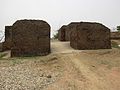

 Centre for Buddhist Culture, also known as the Gompa Temple

_diorama.JPG)
.jpg)

