Jamieson, Oregon
From Wikipedia, the free encyclopedia
Jamieson, Oregon | |
|---|---|
 Abandoned building in Jamieson | |
 Jamieson  Jamieson | |
| Coordinates: 44°10′56″N 117°26′17″W / 44.18222°N 117.43806°W | |
| Country | United States |
| State | Oregon |
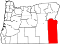
| County | Malheur |
| Elevation | 2,500 ft (760 m) |
| Time zone | UTC-7 (Mountain (MST)) |
| • Summer (DST) | UTC-6 (MDT) |
| ZIP code | 97909 |
| Area code | 541 |
| GNIS feature ID | 1136418[1] |
Jamieson is an unincorporated community in Malheur County, Oregon, United States. The community is 17 miles (27 km) northwest of Vale along U.S. Route 26.[2] Jamieson has a post office with ZIP code 97909.[3]