Jericho, Wayne County, Pennsylvania
From Wikipedia, the free encyclopedia
Jericho, Pennsylvania | |
|---|---|
| Village of Jericho | |
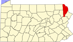
 Jericho Jericho's Location within Pennsylvania. | |
| Coordinates: 41°19′9″N 75°23′26″W / 41.31917°N 75.39056°W | |
| Country | United States |
| State | Pennsylvania |
| U.S. Congressional District | PA-10 |
| School District | Western Wayne Region III |
| County | Wayne |
| Magisterial District | 22-3-01[1] |
| Township | Sterling |
| Settled | c. 1818[2] |
| Founded by | Amasa Megargel[2] |
| Named after | Jericho, Palestine[3] |
| Elevation | 1,570 ft (480 m) |
| Time zone | UTC-5 (Eastern (EST)) |
| • Summer (DST) | UTC-4 (Eastern Daylight (EDT)) |
| ZIP code | |
| Area code | 570 |
| GNIS feature ID | 1203894[6] |
| FIPS code | 42-127-73968[7]-38076[6] |
| Major Roads | |
| Waterways | Butternut Creek,[8] Memory Lake,[9] Rock Port Creek,[10] Lehigh River (West Fork) |
Jericho is a village in Sterling Township, Wayne County, Pennsylvania, United States.