Kampong Thom province
Province of Cambodia
From Wikipedia, the free encyclopedia
Kampong Thom (Khmer: កំពង់ធំ, UNGEGN: Kâmpóng Thum [kɑmpɔŋ tʰom]; lit. 'Great Port') is a province (khaet) of Cambodia. It borders the provinces of Siem Reap to the northwest, Preah Vihear to the north, Stung Treng to the northeast, Kratie to the east, Kampong Cham and Kampong Chhnang to the south, and the Tonle Sap to the west.

Kampong Thom
កំពង់ធំ | |
|---|---|
| Kampong Thom Province ខេត្តកំពង់ធំ | |
Sambor Prei Kuk, a UNESCO World Heritage Site and the symbol of the province | |
 Seal | |
 Map of Cambodia highlighting Kampong Thom | |
| Coordinates: 12°42′N 104°53′E | |
| Country | |
| Provincial status | 1907 |
| Capital | Stung Saen |
| Subdivisions | 1 municipality; 8 districts |
| Government | |
| • Governor | Noun Pharath (CPP) |
| • National Assembly | 6 / 125
|
| Area | |
• Total | 13,814 km2 (5,334 sq mi) |
| • Rank | 2nd |
| Population (2024)[1] | |
• Total | |
| • Rank | 11th |
| • Density | 49/km2 (130/sq mi) |
| • Rank | 17th |
| Time zone | UTC+07:00 (ICT) |
| Dialing code | +855 |
| ISO 3166 code | KH-6 |
| Website | www |
The provincial capital is Stung Saen, a town of approximately 30,000 people on the banks of the Stung Sen River.
Kampong Thom is Cambodia's second largest province by area. There are a number of significant Angkorian sites in the area, including Prasat Sambor Prei Kuk and Prasat Andet temples. As one of the nine provinces bordering Tonle Sap Lake, Kampong Thom is part of the Tonlé Sap Biosphere Reserve.[2]
Etymology
Kampong Thom in Khmer means 'great port' or 'great harbor'. Kampong in Khmer translates as 'port' or 'harbor'. The word Kampong is also shared in other Asian languages, for example in the Malay language, meaning 'village'. Thom in the Khmer language means 'big', 'grand', or 'large'.
Administration
The province is divided into eight districts and one municipality, further divided into 81 communes.
| ISO code | District | Khmer | Population (2019) |
|---|---|---|---|
| 06-01 | Baray | ស្រុកបារាយណ៍ | 104,032 |
| 06-02 | Kampong Svay | ស្រុកកំពង់ស្វាយ | 90,271 |
| 06-03 | Steung Saen Municipality | ក្រុងស្ទឹងសែន | 53,118 |
| 06-04 | Prasat Balangk | ស្រុកប្រាសាទបល្ល័ង្ក | 47,888 |
| 06-05 | Prasat Sambour | ស្រុកប្រាសាទសំបូរ | 43,390 |
| 06-06 | Sandaan | ស្រុកសណ្ដាន់ | 62,013 |
| 06-07 | Santuk | ស្រុកសន្ទុក | 101,428 |
| 06-08 | Stoung | ស្រុកស្ទោង | 108,372 |
| 06-09 | Taing Kouk | ស្រុកតាំងគោក | 64,888 |
History
The previous name of the province was Kampong Pous Thom ('Port', 'City of the Great Snakes'). According to local legend, at a lakeside dock near the Sen River, a pair of large snakes inhabited a nearby cave. On every Buddhist holiday, the snakes would make appearances to the people nearby who then began to refer to the area as Kampong Pous Thom. Eventually the snakes disappeared and the name was shortened to Kampong Thom. During the Colonial Cambodia period, the French divided Cambodian territory into provinces and named most of them according to the local popular names for the respective areas.
Kampong Thom was a powerful capital in Southeast Asia during the Funan period.[citation needed] Prasat Sambor Prei Kuk, dating from the Chenla era, is in Kampong Thom province.[3]


.jpg)
Geography

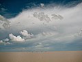
The Prey Lang Wildlife Sanctuary landscape spans Kampong Thom and neighbouring provinces, and has included a registered REDD+ project under Japan’s Joint Crediting Mechanism for which Conservation International Cambodia has been described as a coordinator.[4][5]
Two of the three core areas in Tonlé Sap Biosphere Reserve lie in Kampong Thom.
- Boeng Chhmar (14,560 hectares), and
- Stung Saen (6,355 hectares).[6]
.jpg)
Religion
- Buddhism (98.6%)
- Islam (1.00%)
- Christianity (0.30%)
- Animism and Other religions (0.00%)
The state religion is Theravada Buddhism. More than 98.6% of the people in Kampong Thom are Buddhists. Chams have been practicing Islam for hundreds of years, besides that there are Cham Muslims from Tboung Khmum who came here recently to encroach on the forest land here.[8] A small percentage follow Christianity.
Economy
Much of Kampong Thom is on the floodplain of the Tonlé Sap lake. In 2003–2004, it was a significant producer of wild fish (18,800 tons) and the fourth largest producer of fish through aquaculture in Cambodia (1,800 tons). Most of the fish-raising is done by home production, with a growing segment devoted to rice field aquaculture.[9]
Kampong Thom is also one of the largest producers of cashew nuts in Cambodia, with 6,371 hectares under production in 2003–2004.[10]
 |
 |
.jpg) |
Notable people
- Chhoeung Lvai, Khmer boxer
- Eng Chhai Eang, politician
- Kang Kek Iew, former Khmer Rouge personnel
- Ke Pauk, former Khmer Rouge personnel
- Kouch Sokumpheak, footballer
- Nguon Nhel, politician
- Pol Pot, former Khmer Rouge dictator and Prime Minister
Attraction
 Tonle Sap See
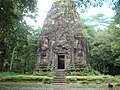 Sambor Prei Kuk
 Phnom Santuk
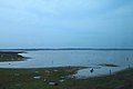 Prey Pras


