Kasterlee
Municipality in Flemish Community, Belgium
From Wikipedia, the free encyclopedia
Kasterlee (Dutch pronunciation: [ˈkɑstərleː]) is a municipality located in the Belgian province of Antwerp. The municipality comprises the towns of Kasterlee proper, Lichtaart and Tielen. In 2021, Kasterlee had a total population of 19,052. The total area is 71.56 km2.[2] The town is twinned with Plaffeien (Switzerland).
.jpg)
Kasterlee
| |
|---|---|
| |
 Flag  Coat of arms | |
 Location of Kasterlee in the province of Antwerp | |
 Interactive map of Kasterlee | |
 Kasterlee Location in Belgium | |
| Coordinates: 51°15′N 04°57′E | |
| Country | Belgium |
| Community | Flemish Community |
| Region | Flemish Region |
| Province | Antwerp |
| Arrondissement | Turnhout |
| Government | |
| • Mayor | Ward Kennes (CD&V) |
| • Governing party | CD&V |
| Area | |
• Total | 72.27 km2 (27.90 sq mi) |
| Population (2020-01-01)[1] | |
• Total | 18,882 |
| • Density | 261.3/km2 (676.7/sq mi) |
| Postal codes | 2460 |
| NIS code | 13017 |
| Area codes | 014 |
| Website | www.kasterlee.be |
Notable Person
- Baron Bob Stouthuysen (b. 10 March 1929), businessman.
Gallery
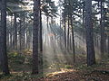 Crepuscular rays in the woods of Kasterlee
 the Kleine Nete in Kasterlee
 Keeses Molen


