Kenwood Estates, Florida
From Wikipedia, the free encyclopedia
Kenwood Estates, Florida | |
|---|---|
  Kenwood Estates, Florida | |
| Coordinates: 26°37′39″N 80°06′55″W / 26.62750°N 80.11528°W | |
| Country | United States |
| State | Florida |
| County | Palm Beach |
| Area | |
• Total | 0.17 sq mi (0.45 km2) |
| • Land | 0.17 sq mi (0.45 km2) |
| • Water | 0 sq mi (0.00 km2) |
| Elevation | 16 ft (4.9 m) |
| Population (2020) | |
• Total | 1,435 |
| • Density | 8,219.6/sq mi (3,173.61/km2) |
| Time zone | UTC-5 (Eastern (EST)) |
| • Summer (DST) | UTC-4 (EDT) |
| Area codes | 561, 728 |
| GNIS feature ID | 2628522[2] |
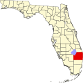
Kenwood Estates is a census-designated place (CDP) in Palm Beach County, Florida, United States. It is part of the Miami metropolitan area of South Florida. The population had 1,435 residents as of the 2020 census.
Kenwood Estates is located between Greenacres and Palm Springs; State Road 809 (Military Trail) passes through the community. More specifically, the CDP is defined from Attleboro Avenue westward to Haverhill Road, while the community's southern boundary is the L-11 Canal and the northern extent is generally along the southside of 10th Avenue North.[3]