Kirumampakkam
From Wikipedia, the free encyclopedia
Kirumampakkam | |
|---|---|
Village | |
 Kirumampakkam Location in Puducherry, India  Kirumampakkam Kirumampakkam (India) | |
| Coordinates: 11°49′13″N 79°47′09″E / 11.820204°N 79.785891°E | |
| Country | |
| State | Puducherry |
| District | Pondicherry |
| Taluk | Bahour |
| Commune | Bahour |
| Languages | |
| • Official | French, Tamil, English |
| Time zone | UTC+5:30 (IST) |
| PIN | 607 402 |
| Telephone code | 0413 |
| Vehicle registration | PY-01 |
| Sex ratio | 50% ♂/♀ |
Kirumampakkam is a village[1] in Bahour Commune of Bahour taluk in the Union Territory of Puducherry, India. It lies on Cuddalore road (NH-45A) at a distance of 15 km from Pondicherry.
Kirumampakkam is bordered by Nagappanur village of Tamil Nadu in the west, Madalapattu village of Tamil Nadu in the north, Pannithittu in the east and Pillaiyarkuppam in the south.
Road network
Kirumampakkam is connected to Puducherry by Cuddalore road (NH-45A). Also, Kirumampakkam-Bahour road (RC-27) connects Kirumampakkam with Bahour, its Commune Headquarters. Kirumampakkam provides gateway to Nagappanur village of Tamil Nadu.
Gallery
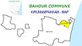 Map of Kirumampakkam Village Panchayat
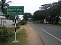 Kirumambakkam, Bahour Commune
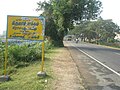 Welcome to Kirumambakkam Village Panchayat, Bahour Commune


