Kota Kinabalu District
From Wikipedia, the free encyclopedia
Kota Kinabalu District
Daerah Kota Kinabalu | |
|---|---|
.jpg) Kota Kinabalu City Hall. | |
 Flag  Seal | |
 | |
| Coordinates: 5°58′13″N 116°04′14″E / 5.97028°N 116.07056°E | |
| Country | |
| State | |
| Division | West Coast |
| Capital | Kota Kinabalu |
| Government | |
| • Mayor of City Council | Datuk Dr. Sabin Samitah |
| • MP | |
| • MLA |
|
| Area | |
• Total | 352 km2 (136 sq mi) |
| Population (2020[1]) | |
• Total | 500,425 |
| • Density | 1,420/km2 (3,680/sq mi) |
| Website | dbkk |

The Kota Kinabalu District (Malay: Daerah Kota Kinabalu) is an administrative district in the Malaysian state of Sabah, part of the West Coast Division which includes the districts of Kota Belud, Kota Kinabalu, Papar, Penampang, Ranau and Tuaran. The capital of the district is in Kota Kinabalu City.
| Year | Pop. | ±% |
|---|---|---|
| 1991 | 209,175 | — |
| 2000 | 355,435 | +69.9% |
| 2010 | 452,058 | +27.2% |
| 2020 | 500,421 | +10.7% |
| Source: [2] | ||
According to the 2020 census, the population of the district was 500,421. The main ethnic groups were the Chinese (20%), Kadazan-Dusun (15%), Bajaus (16%), Malays (8%) and Muruts (6%).[2] As in most other parts of Sabah, there was also a significant number of illegal immigrants from the southern Philippines - mainly from the Sulu Archipelago and Mindanao - many of whom are not included in the population statistics.
Gallery

 Kota Kinabalu Basel Church.
 Mary Immaculate Catholic Church.
 Kota Kinabalu Latter Day Saint Church.
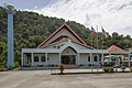 Kota Kinabalu Seventh Day Adventist Church.

 Gurdwara Sahib Kota Kinabalu.
 Kota Kinabalu city centre.


