
La Chapelle-de-Surieu
Commune in Auvergne-Rhône-Alpes, France
From Wikipedia, the free encyclopedia
La Chapelle-de-Surieu (French pronunciation: [la ʃapɛl də syʁjø]) is a commune in the Isère department in southeastern France.

La Chapelle-de-Surieu | |
|---|---|
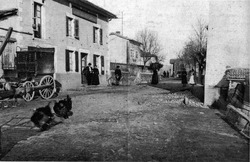 A view of La Chapelle de Surieu, in 1909 | |
 Location of La Chapelle-de-Surieu | |
 La Chapelle-de-Surieu  La Chapelle-de-Surieu | |
| Coordinates: 45°23′31″N 4°54′38″E | |
| Country | France |
| Region | Auvergne-Rhône-Alpes |
| Department | Isère |
| Arrondissement | Vienne |
| Canton | Roussillon |
| Government | |
| • Mayor (2020–2026) | Gabriel Girard[1] |
Area 1 | 11.22 km2 (4.33 sq mi) |
| Population (2023)[2] | 757 |
| • Density | 67.5/km2 (175/sq mi) |
| Time zone | UTC+01:00 (CET) |
| • Summer (DST) | UTC+02:00 (CEST) |
| INSEE/Postal code | 38077 /38150 |
| Elevation | 252–407 m (827–1,335 ft) |
| 1 French Land Register data, which excludes lakes, ponds, glaciers > 1 km2 (0.386 sq mi or 247 acres) and river estuaries. | |
Population
| Year | Pop. | ±% p.a. |
|---|---|---|
| 1968 | 345 | — |
| 1975 | 289 | −2.50% |
| 1982 | 326 | +1.74% |
| 1990 | 409 | +2.88% |
| 1999 | 477 | +1.72% |
| 2007 | 632 | +3.58% |
| 2012 | 712 | +2.41% |
| 2017 | 751 | +1.07% |
| 2023 | 757 | +0.13% |
| Source: INSEE[3] | ||