La Junta Gardens, Colorado
From Wikipedia, the free encyclopedia
La Junta Gardens, Colorado | |
|---|---|
 Looking north along Jachim Avenue | |
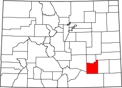
 Location of the La Junta Gardens CDP in Otero County, Colorado. | |
  La Junta Gardens Location of the La Junta Gardens CDP in the United States. | |
| Coordinates: 38°00′05″N 103°33′17″W / 38.0013489°N 103.5548501°W[1] | |
| Country |  United States United States |
| State |  Colorado Colorado |
| County | Otero County |
| Government | |
| • Type | unincorporated community |
| Area | |
• Total | 0.533 sq mi (1.381 km2) |
| • Land | 0.533 sq mi (1.381 km2) |
| • Water | 0 sq mi (0.000 km2) |
| Elevation | 4,065 ft (1,239 m) |
| Population | |
• Total | 123 |
| • Density | 231/sq mi (89.1/km2) |
| Time zone | UTC-7 (MST) |
| • Summer (DST) | UTC-6 (MDT) |
| ZIP Code[3] | La Junta 81050 |
| Area codes | 970 |
| GNIS feature[2] | La Junta Gardens CDP |
La Junta Gardens is a Census-designated place (CDP) in and governed by Otero County, Colorado, United States. The population of the La Junta Gardens CDP was 123 at the United States Census 2020.[1] The La Junta post office (Zip Code 81050) serves the area.[3]
The La Junta Gardens CDP has an area of 341 acres (1.381 km2), all land.[1]
Demographics
| Year | Pop. | ±% |
|---|---|---|
| 2010 | 153 | — |
| 2020 | 123 | −19.6% |
| Source: United States Census Bureau | ||
The United States Census Bureau initially defined the La Junta Gardens CDP for the United States Census 2010.