Lautertal (Odenwald)
From Wikipedia, the free encyclopedia
Lautertal | |
|---|---|
.png) Coat of arms | |
Location of Lautertal
within Bergstraße district 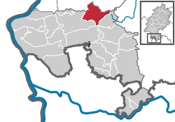 | |
 Location of Lautertal | |
 Lautertal  Lautertal | |
| Coordinates: 49°44′N 8°42′E / 49.733°N 8.700°E | |
| Country | Germany |
| State | Hesse |
| Admin. region | Darmstadt |
| District | Bergstraße |
| Government | |
| • Mayor (2017–23) | Andreas Heun[1] |
| Area | |
• Total | 30.75 km2 (11.87 sq mi) |
| Elevation | 200 m (660 ft) |
| Population (2023-12-31)[2] | |
• Total | 7,167 |
| • Density | 233.1/km2 (603.7/sq mi) |
| Time zone | UTC+01:00 (CET) |
| • Summer (DST) | UTC+02:00 (CEST) |
| Postal codes | 64686 |
| Dialling codes | 06254, 06251 (Elmshausen) |
| Vehicle registration | HP |
| Website | www.lautertal.de |
Lautertal (Odenwald) (German pronunciation: [ˈlaʊtɐtaːl], lit. 'Lauter Valley') is a municipality in the Bergstraße district in the Hessian Odenwald in Germany that came into being with the merger of several former communities.
Location
The Lauter valley (also called the Lautertal in German) begins near the source of the brook called the Lauter, which is found on the Neunkircher Höhe (“Neunkirchen Heights”). The brook then runs first along a broad streambed, but then gets quite narrow and steep as it approaches the Bergstraße, where the brook's name becomes the Winkelbach once it reaches Bensheim. Furthermore, the valley includes several peaks on both sides.
Neighbouring communities
Lautertal borders in the north on the communities of Seeheim-Jugenheim and Modautal (Darmstadt-Dieburg), in the east on the town of Lindenfels, in the south on the community of Fürth and the town of Heppenheim and in the west on the town of Bensheim.
History


The community of Lautertal came into being through municipal reform on 1 January 1972. The formerly self-governing communities of Beedenkirchen, Elmshausen, Gadernheim, Lautern, Raidelbach, Reichenbach, Staffel and Wurzelbach merged voluntarily, but later the same year, the communities of Knoden and Schannenbach were forcibly merged with Lautertal, and so was Schmal-Beerbach in 1978.
Some of the individual constituent communities had their beginnings in Roman times and the Middle Ages (of a castle that supposedly once stood near Gadernheim, there is no trace today).
Politics
Community council
The municipal election held on 26 March 2006 yielded the following results:
| Parties and voter communities | % 2006 |
Seats 2006 |
% 2001 |
Seats 2001 | |
| CDU | Christian Democratic Union of Germany | 33.7 | 10 | 30.8 | 10 |
| SPD | Social Democratic Party of Germany | 50.6 | 16 | 51.8 | 16 |
| FDP | Free Democratic Party | 2.2 | 1 | – | – |
| FWGL | Freie Wählergemeinschaft Lautertal | 7.0 | 2 | 10.3 | 3 |
| GLL | Grüne Liste Lautertal | 6.4 | 2 | 7.1 | 2 |
| Total | 100.0 | 31 | 100.0 | 31 | |
| Voter turnout in % | 54.3 | 59.2 | |||
Mayor
Andreas Heun (SPD) is Lautertal's mayor since 2018.
Town partnerships
 Parish of Aldenham, Hertfordshire, England, United Kingdom since 25 October 1980
 Jarnac, Charente, France since 4 September 1982


