Lehesten
From Wikipedia, the free encyclopedia
Lehesten | |
|---|---|
 Coat of arms | |
Location of Lehesten
within Saalfeld-Rudolstadt district 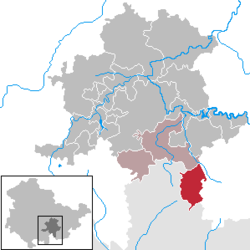 | |
 Location of Lehesten | |
 Lehesten  Lehesten | |
| Coordinates: 50°28′32″N 11°26′53″E / 50.47556°N 11.44806°E | |
| Country | Germany |
| State | Thuringia |
| District | Saalfeld-Rudolstadt |
| Municipal assoc. | Schiefergebirge |
| Subdivisions | 3 |
| Government | |
| • Mayor (2021–27) | Nicole Vockeroth[1] |
| Area | |
• Total | 35.94 km2 (13.88 sq mi) |
| Elevation | 640 m (2,100 ft) |
| Population (2023-12-31)[2] | |
• Total | 1,555 |
| • Density | 43.27/km2 (112.1/sq mi) |
| Time zone | UTC+01:00 (CET) |
| • Summer (DST) | UTC+02:00 (CEST) |
| Postal codes | 07349 |
| Dialling codes | 036653 |
| Vehicle registration | SLF |
| Website | www.lehesten.de |
Lehesten (German pronunciation: [ˈleːəstn̩] ⓘ) is a town in the Thuringian Forest, 20 km southeast of Saalfeld.
