Lewis, Wisconsin
From Wikipedia, the free encyclopedia
Lewis, Wisconsin | |
|---|---|
Census-designated place | |
 Lewis, Wisconsin | |
| Coordinates: 45°42′39″N 92°24′09″W / 45.71083°N 92.40250°W | |
| Country | United States |
| State | Wisconsin |
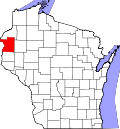
| County | Polk |
| Area | |
• Total | 1.460 sq mi (3.78 km2) |
| • Land | 1.454 sq mi (3.77 km2) |
| • Water | 0.006 sq mi (0.016 km2) |
| Elevation | 1,050 ft (320 m) |
| Population | |
• Total | 87 |
| • Density | 60/sq mi (23/km2) |
| Time zone | UTC-6 (Central (CST)) |
| • Summer (DST) | UTC-5 (CDT) |
| Area codes | 715 & 534 |
| GNIS feature ID | 1567997[2] |
Lewis is an unincorporated census-designated place in the town of Clam Falls, Polk County, Wisconsin, United States. Lewis is located on Wisconsin Highway 35, 4.5 miles (7.2 km) northeast of Frederic. As of the 2020 census, its population was 87.[3]
| Census | Pop. | Note | %± |
|---|---|---|---|
| 2010 | 164 | — | |
| 2020 | 87 | −47.0% | |
| U.S. Decennial Census[4] | |||