Lindley Hall Farm
From Wikipedia, the free encyclopedia
| Lindley Hall Farm | |
|---|---|
 An image taken at Lindley Hall Farm, at the point which the Ordnance Survey calculated to be the geographical centre of England. | |
 Location of Lindley Hall Farm | |
| Town/City | Hinckley and Bosworth, Leicestershire, England |
| Coordinates | 52°33′38″N 1°28′13″W / 52.56056°N 1.47028°W |
| Owner | Stephen Farmer |
Lindley Hall Farm is a farm in Leicestershire, England, in close proximity to Fenny Drayton and Higham on the Hill. The farm is owned by Stephen Farmer. It has been best known as the geographical centre of England since the Ordnance Survey's investigation in 2002. A plaque has been erected by the Ordnance Survey denoting the geographical central point and disputing the historically believed idea that Meriden was the geographical centre.
Gallery
It is unknown when the farm was established, but it was named after the nearby former Lindley Hall, which was once present on the Leicestershire countryside near Higham on the Hill. Five years following the death of the Lindley Hall estate's owner (Lieutenant Commander Francis Eyre RN), Lindley Hall and the Roman Catholic chapel beside it were ultimately demolished, being one of the country houses and estates in the Nuneaton area to fall victim to redevelopment. However, the remains of the old chapel and hall remain at Lindley House, which is built at Lindley Park on the former site of Lindley Hall.[1]
Having been in ownership of the Farmer family, Lindley Hall Farm used to be a dairy farm. However, after an outbreak of foot-and-mouth disease, all of the farm's animals were killed, leading to the farm halting the production of dairy. Following this, the farm would go on to cultivate sheep, cattle, wheat, oats and barley.[2]
 "Lindley hall from Lake Tiny", J._M._W._Turner
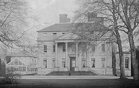 Lindley Hall, Leicestershire, prior to demolition.
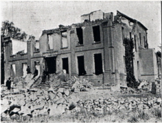 Lindley Hall in the process of being demolished, 22 May 1925.
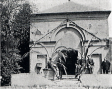 Lindley Chapel, which was demolished alongside Lindley Hall on 22 May 1925.
.jpg)


