List of beaches in Barbados
From Wikipedia, the free encyclopedia
The island country of Barbados has more than 70 miles (110 km) of beaches of both pink and white sands, which are made of coral reefs that have been ground into a very fine powder by the waves of the ocean. Beaches on Barbados can be categorized by region: north and east coast beaches, south coast beaches, and west coast beaches. East and north coast beaches are facing the Atlantic Ocean, while the waters of the southern beaches are a combination of both the Atlantic Ocean and Caribbean Sea. The west coast, or the Platinum Coast, beaches are brimmed by the warm waters of the Caribbean. This is a list of many of the beaches located in Barbados. There are no private beaches on the island.[1][2][3][4][5]

Beaches

There are 61 beaches in Barbados, including the following with the parishes indicated for each beach:
| Beach | Parish | Coor/Refs |
|---|---|---|
| Accra Beach | Christ Church | 13°04′00″N 59°33′42″W[1] |
| Alleyne Beach | Saint James | |
| Barclays Park Beach | Saint Joseph | 13°14′11″N 59°32′36″W[5][6] |
| Bathsheba Beach | Saint Joseph | 13°12′52″N 59°31′23″W[1][6][5] |
| Bath Beach | Saint John | 13°11′15″N 59°28′36″W[1][6][5] |
| Batts Rock | Saint Miachael | 13°08′07″N 59°38′11″W[1][6][5] |
| Bottom Bay beach | Saint Philip | 13°08′10″N 59°25′28″W[1][6][5] |
| Brandons Beach | Saint Michael | 13°06′57″N 59°37′38″W[1][6][5] |
| Brighton Beach | Saint Michael | 13°07′20″N 59°37′52″W[1][6][5] |
| Brownes Beach | Saint Michael | 13°05′10″N 59°36′35″W[1][6] |
| Carlisle Bay | Saint Michael | 13°05′N 59°37′W[1][5] |
| Care Bay | Saint Philip | [5] |
| Casuarina Beach | Christ Church | [7] |
| Cattlewash | Saint Joseph | 13°13′21″N 59°31′55″W[1][6][5] |
| The Chase Beach | Saint Andrew | 13°16′28″N 59°34′00″W[2] |
| Cotton House Bay | Christ Church | [5] |
| Crane Beach | Saint Philip | 13°06′24″N 59°26′38″W[2][1][5] |
| Culpepper Island | Saint Philip | 13°09′58″N 59°26′36″W[5][6] |
| Dover Beach | Christ Church | 13°04′00″N 59°34′10″W[2][1][5] |
| Drill Haul Beach | Saint Michael | 13°04′40″N 59°36′31″W[5] |
| Fitts Village | Saint James | [5] |
| Foul Bay Beach | Saint Philip | 13°06′04″N 59°27′03″W[5][6] |
| Freights Beach | Christ Church | 13°03′12″N 59°32′14″W[5][6] |
| Freshwater Bay | Saint Michael | 13°07′50″N 59°38′09″W[8][9] |
| Garrison Beach | Christ Church | |
| Gibbes Beach | Saint Peter | 13°13′54″N 59°38′35″W[1] |
| Ginger Bay (aka Shanty Bay) | Saint Philip | 13°06′42″N 59°26′28″W[5] |
| Heywoods Beach | Saint Peter | 13°15′25″N 59°38′39″W[2][1][6][5] |
| Inch Marlow Beach | Christ Church | [5] |
| Lakes Beach | Saint Andrew | 13°14′21″N 59°32′43″W[2] |
| Little Bay | Saint Lucy | 13°18′36″N 59°34′44″W[1][6] |
| Long Bay Beach | Christ Church | 13°03′46″N 59°29′52″W[5] |
| Maycock's Bay | Saint Lucy | 13°17′45″N 59°39′00″W[5][6] |
| Maxwell Beach | Christ Church | 13°04′00″N 59°33′00″W[2][1][6][5] |
| Miami Beach (aka Enterprise Beach) | Christ Church | 13°3′35″N 59°32′23″W[1][5] |
| Morgan Lewis Beach | Saint Andrew | 13°16′10″N 59°33′51″W[2][1][5] |
| Mullins Beach | Saint Peter | 13°14′04″N 59°38′34″W[1][6][5] |
| Needham Point Beach | Saint Michael | 13°04′42″N 59°36′42″W[5][6] |
| Paradise Beach | Saint Michael | 13°07′49″N 59°38′05″W[1][6][5] |
| Paynes Bay | Saint Thomas | 13°10′N 59°38′W[1][6][5] |
| Pebbles Beach | Saint Michael | 13°05′14″N 59°36′35″W[1][5] |
| River Bay | Saint Lucy | 13°19′24″N 59°35′44″W[1][6][5] |
| Rockley Beach | Christ Church | 13°04′25″N 59°35′21″W[2] |
| Saint Lawrence Gap | Christ Church | [5] |
| Sam Lord's Castle | Saint Philip | [5] |
| Sandy Lane Bay | Saint James | 13°10′27″N 59°38′16″W[5][6] |
| Shark's Hole Bay | Saint Philip | 13°07′13″N 59°26′01″W[1][6] |
| Silver Rock Beach-Round Rock | Christ Church | [5] |
| Silver Sands Beach | Christ Church | 13°02′50″N 59°31′03″W[10][5] |
| Walkers Beach | Saint Andrew | 13°15′25″N 59°33′27″W[2][1] |
| Welches Beach | Christ Church | 13°03′55″N 59°32′55″W[1][6] |
| Worthing Beach (aka Sandy Beach) | Christ Church | 13°04′16″N 59°34′59″W[2][1][5] |
Gallery
 Bathsheba Beach
 Bel Air Beach
 Bottom Bay
 Brandon's Beach
 Butterfly Beach
 Carllisle Bay
 Cave Bay
 Crane Beach
 Dovere Beach
 Drill Hall Beach
 Foul Bay
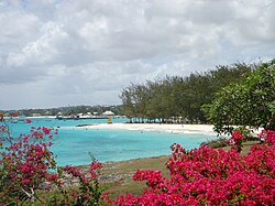 Miami Beach
 Moamo Beach
 Moody Beach
 Shark's Hole Beach
 Worthing Beach


.jpg)


.jpg)


