| Name |
Address |
Coordinates |
Government recognition (CRHP №) |
 |
Image |
|---|
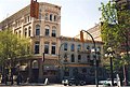
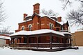
| Grey Nuns' Convent National Historic Site of Canada |
494 Tache Avenue
St. Boniface MB |
49°53′16″N 97°07′25″W / 49.8878°N 97.1236°W / 49.8878; -97.1236 (Grey Nuns' Convent National Historic Site of Canada) |
Federal (7420),
Manitoba (8608),
St. Boniface municipality (8607) |
|

More images |
| Cathedral Church of Saint John |
135 Anderson Avenue
Winnipeg MB |
49°55′14″N 97°07′31″W / 49.920488°N 97.125230°W / 49.920488; -97.125230 (Cathedral Church of St. John) |
Manitoba (4508) |
|
 |
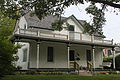
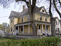
| Bernier House |
265 Provencher Boulevard
Winnipeg MB |
49°53′N 97°07′W / 49.89°N 97.12°W / 49.89; -97.12 (Bernier House) |
Manitoba (4151),
Winnipeg municipality (7752) |
|

More images |
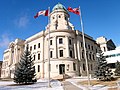
| St. Boniface City Hall National Historic Site of Canada |
219 Provencher Boulevard
St. Boniface MB |
49°53′34″N 97°07′17″W / 49.8927°N 97.1213°W / 49.8927; -97.1213 (St. Boniface City Hall National Historic Site of Canada) |
Federal (4444),
St. Boniface municipality (5924) |
|

More images |
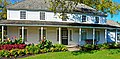
| Maison Kittson |
165 La Verendrye Street
Winnipeg MB |
49°53′41″N 97°07′29″W / 49.8947°N 97.1247°W / 49.8947; -97.1247 (Maison Kittson) |
Winnipeg municipality (7365) |
|
More images |
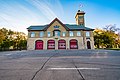
| St. Boniface Fire Hall No. 1 |
212 Rue Dumoulin
Winnipeg MB |
49°53′36″N 97°07′15″W / 49.8932°N 97.1209°W / 49.8932; -97.1209 (St. Boniface Fire Hall No. 1) |
Winnipeg municipality (8043) |
|

More images |
| Belgian War Memorial |
Provencher Boulevard
Winnipeg MB |
49°53′42″N 97°06′40″W / 49.8949°N 97.1112°W / 49.8949; -97.1112 (Belgian War Memorial) |
Winnipeg municipality (8134) |
|

More images |
| Belgian Club |
407 Provencher Boulevard
Winnipeg MB |
49°53′43″N 97°06′40″W / 49.8952°N 97.1112°W / 49.8952; -97.1112 (Belgian Club) |
Winnipeg municipality (8232) |
|

More images |
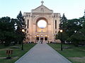
| St. Boniface Cathedral |
190 Cathedral Avenue
Winnipeg MB |
49°53′21″N 97°07′20″W / 49.8893°N 97.1223°W / 49.8893; -97.1223 (St. Boniface Cathedral) |
Manitoba (8394) |
|
More images |
| St. Boniface Hospital Nurses' Residence National Historic Site of Canada |
409 Tache Avenue
Winnipeg MB |
49°53′08″N 97°07′26″W / 49.8856°N 97.1238°W / 49.8856; -97.1238 (St. Boniface Hospital Nurses' Residence National Historic Site of Canada) |
Federal (13401) |
|

More images |
| St. Boniface Normal School |
210 Masson Street
Winnipeg MB |
49°53′29″N 97°07′14″W / 49.8913°N 97.1205°W / 49.8913; -97.1205 (St. Boniface Normal School) |
Winnipeg municipality (13545) |
|

More images |
| St. Boniface Waterworks Water Tower |
552 Plinguet Street
Winnipeg MB |
49°53′33″N 97°06′06″W / 49.8926°N 97.1016°W / 49.8926; -97.1016 (St. Boniface Waterworks Water Tower) |
Winnipeg municipality (8133) |
|
 |
| Greater Winnipeg Water District Railway Station |
598 Plinguet Street
Winnipeg MB |
49°53′36″N 97°06′00″W / 49.8932°N 97.1°W / 49.8932; -97.1 (Greater Winnipeg Water District Railway Station) |
Winnipeg municipality (8223) |
|
 |
| Fire Hall No. 8 |
325 Talbot Avenue
Winnipeg MB |
49°54′28″N 97°06′37″W / 49.9077°N 97.1102°W / 49.9077; -97.1102 (Fire Hall No. 8) |
Winnipeg municipality (7909) |
|
 |
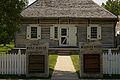
| Riel House National Historic Site of Canada |
330 River Road
Winnipeg MB |
49°49′09″N 97°08′10″W / 49.8192°N 97.1362°W / 49.8192; -97.1362 (Riel House National Historic Site of Canada) |
Federal (7762),
Manitoba (9528) |
|

More images |
| St. Vital Firehall |
598-600 St. Mary's Road
Winnipeg MB |
49°51′49″N 97°06′41″W / 49.8635°N 97.1115°W / 49.8635; -97.1115 (St. Vital Firehall) |
Winnipeg municipality (8214) |
|
 |
| Red River Floodway National Historic Site of Canada |
Winnipeg MB |
49°45′05″N 97°07′58″W / 49.7514°N 97.1328°W / 49.7514; -97.1328 (Red River Floodway National Historic Site of Canada) |
Federal (13693) |
|

More images |
| Kildonan School |
2373 Main Street
Winnipeg MB |
49°57′13″N 97°05′51″W / 49.9537°N 97.0975°W / 49.9537; -97.0975 (Kildonan School) |
Manitoba (4599) |
|

Upload Photo |
| Kildonan Presbyterian Church |
201 John Black Avenue
Winnipeg MB |
49°57′11″N 97°05′56″W / 49.9531°N 97.0988°W / 49.9531; -97.0988 (Kildonan Presbyterian Church) |
Manitoba (6748),
Winnipeg municipality (4639) |
|
 |
| Seven Oaks Museum |
115 Rupertsland Blvd.
Winnipeg MB |
49°55′49″N 97°07′00″W / 49.9302°N 97.1168°W / 49.9302; -97.1168 (Seven Oaks Museum) |
Winnipeg municipality (5925) |
|
 |
| Inkster House |
1637 Main Street
Winnipeg MB |
49°55′58″N 97°07′12″W / 49.9329°N 97.1199°W / 49.9329; -97.1199 (Inkster House) |
Winnipeg municipality (5931) |
|
Upload Photo |
| McBeth House |
31 McBeth Street
Winnipeg MB |
49°57′23″N 97°05′06″W / 49.9563°N 97.0849°W / 49.9563; -97.0849 (McBeth House) |
Winnipeg municipality (8191) |
|
Upload Photo |
| St. John's Telephone Exchange Building |
405 Burrows Avenue
Winnipeg MB |
49°55′03″N 97°08′16″W / 49.9175°N 97.1379°W / 49.9175; -97.1379 (St. John's Telephone Exchange Building) |
Manitoba (4353) |
|
Upload Photo |
| North End Police Substation |
200 Charles Street
Winnipeg MB |
49°54′54″N 97°08′06″W / 49.915°N 97.1351°W / 49.915; -97.1351 (North End Police Substation) |
Winnipeg municipality (6031) |
|
Upload Photo |
| Bethlehem Aboriginal Fellowship Church |
294 Burrows Avenue
Winnipeg MB |
49°54′56″N 97°08′05″W / 49.9155°N 97.1348°W / 49.9155; -97.1348 (Bethlehem Aboriginal Fellowship Church) |
Winnipeg municipality (7908) |
|
 |
| All People's Sutherland Mission |
119 Sutherland Avenue
Winnipeg MB |
49°54′21″N 97°07′39″W / 49.9059°N 97.1275°W / 49.9059; -97.1275 (All People's Sutherland Mission) |
Winnipeg municipality (8122) |
|
Upload Photo |
| St. John's Presbyterian Church |
251 Bannerman Avenue
Winnipeg MB |
49°55′32″N 97°07′37″W / 49.9256°N 97.127°W / 49.9256; -97.127 (St. John's Presbyterian Church) |
Winnipeg municipality (8584) |
|
Upload Photo |
| St. John's Church |
250 Cathedral Avenue
Winnipeg MB |
49°55′28″N 97°07′41″W / 49.9244°N 97.128°W / 49.9244; -97.128 (St. John's Church) |
Winnipeg municipality (8585) |
|
Upload Photo |
| St. Michael's Ukrainian Orthodox Church |
110 Disraeli Street
Winnipeg MB |
49°54′21″N 97°07′30″W / 49.9059°N 97.125°W / 49.9059; -97.125 (St. Michael's Ukrainian Orthodox Church) |
Winnipeg municipality (11537) |
|
Upload Photo |
| Ukrainian Labour Temple National Historic Site of Canada |
591-595 Pritchard Avenue
Winnipeg MB |
49°55′04″N 97°08′55″W / 49.9179°N 97.1485°W / 49.9179; -97.1485 (Ukrainian Labour Temple National Historic Site of Canada) |
Federal (13921),
Manitoba (3954),
Winnipeg municipality (6725) |
|
|
| Scott Fruit Company Warehouse |
319 Elgin Avenue
Winnipeg MB |
49°54′03″N 97°08′30″W / 49.9009°N 97.1417°W / 49.9009; -97.1417 (Scott Fruit Company Warehouse) |
Winnipeg municipality (3022) |
|
Upload Photo |
| Central Normal School (Winnipeg) |
442 William Avenue
Winnipeg MB |
49°54′05″N 97°08′52″W / 49.9015°N 97.1479°W / 49.9015; -97.1479 (Central Normal School (Winnipeg)) |
Manitoba (3908),
Winnipeg municipality (8309) |
|
 |
| First Scandinavian Mission Church |
268 Ellen Street
Winnipeg MB |
49°54′00″N 97°08′46″W / 49.9001°N 97.146°W / 49.9001; -97.146 (First Scandinavian Mission Church) |
Manitoba (3973),
Winnipeg municipality (7336) |
|
Upload Photo |
| Garry Telephone Exchange Building |
474 Hargrave Street
Winnipeg MB |
49°54′N 97°09′W / 49.9°N 97.15°W / 49.9; -97.15 (Garry Telephone Exchange Building) |
Manitoba (4175) |
|
Upload Photo |
| W.M. Ashdown House |
121 Kate Street
Winnipeg MB |
49°54′09″N 97°09′07″W / 49.9024°N 97.1519°W / 49.9024; -97.1519 (W.M. Ashdown House) |
Winnipeg municipality (5594) |
|
Upload Photo |
| Gault Building |
100 Arthur Street
Winnipeg MB |
49°53′54″N 97°08′33″W / 49.8984°N 97.1424°W / 49.8984; -97.1424 (Gault Building) |
Winnipeg municipality (5845) |
|
Upload Photo |
| Penrose House |
444 Logan Avenue
Winnipeg MB |
49°54′19″N 97°08′41″W / 49.9052°N 97.1448°W / 49.9052; -97.1448 (Penrose House) |
Winnipeg municipality (6075) |
|
Upload Photo |
| McCormicks Limited Building |
425 Henry Avenue
Winnipeg MB |
49°54′23″N 97°08′34″W / 49.9065°N 97.1429°W / 49.9065; -97.1429 (McCormicks Limited Building) |
Winnipeg municipality (6096) |
|
Upload Photo |
| Drake Hotel |
146 Princess Street
Winnipeg MB |
49°54′00″N 97°08′30″W / 49.9°N 97.1416°W / 49.9; -97.1416 (Drake Hotel) |
Winnipeg municipality (7347) |
|
 |
| House of Comoy |
150 Princess Street
Winnipeg MB |
49°54′00″N 97°08′29″W / 49.9001°N 97.1415°W / 49.9001; -97.1415 (House of Comoy) |
Winnipeg municipality (7349) |
|
Upload Photo |
| Hochman Building |
154 Princess Street
Winnipeg MB |
49°54′00″N 97°08′29″W / 49.9001°N 97.1414°W / 49.9001; -97.1414 (Hochman Building) |
Winnipeg municipality (7350) |
|
 |
| Exchange Building |
160 Princess Street
Winnipeg MB |
49°54′01″N 97°08′29″W / 49.9002°N 97.1414°W / 49.9002; -97.1414 (Exchange Building) |
Winnipeg municipality (7351) |
|
Upload Photo |
| Utility Building |
164 Princess Street
Winnipeg MB |
49°54′01″N 97°08′29″W / 49.9004°N 97.1413°W / 49.9004; -97.1413 (Utility Building) |
Winnipeg municipality (7359) |
|

More images |
| Adelman Building |
92-100 Princess Street
Winnipeg MB |
49°53′54″N 97°08′33″W / 49.8984°N 97.1424°W / 49.8984; -97.1424 (Adelman Building) |
Winnipeg municipality (7741) |
|
Upload Photo |
| Bathgate Block |
242 Princess Street
Winnipeg MB |
49°54′10″N 97°08′22″W / 49.9027°N 97.1395°W / 49.9027; -97.1395 (Bathgate Block) |
Winnipeg municipality (8051) |
|
 |
| Ryan Block |
44 Princess Street
Winnipeg MB |
49°53′49″N 97°08′38″W / 49.8969°N 97.1439°W / 49.8969; -97.1439 (Ryan Block) |
Winnipeg municipality (8237) |
|
Upload Photo |
| Stovel Printing Building |
365 Bannatyne Avenue
Winnipeg MB |
49°54′00″N 97°08′43″W / 49.9°N 97.1454°W / 49.9; -97.1454 (Stovel Printing Building) |
Winnipeg municipality (8583) |
|
Upload Photo |
| Sterling Cloak Building |
110 Princess Street
Winnipeg MB |
49°53′57″N 97°08′32″W / 49.8991°N 97.1421°W / 49.8991; -97.1421 (Sterling Cloak Building) |
Winnipeg municipality (8610) |
|
Upload Photo |
| Frost and Wood Warehouse |
230 Princess Street
Winnipeg MB |
49°54′08″N 97°08′23″W / 49.9022°N 97.1397°W / 49.9022; -97.1397 (Frost and Wood Warehouse) |
Winnipeg municipality (8669) |
|
Upload Photo |
| Henderson Building |
332 Bannatyne Avenue
Winnipeg MB |
49°53′56″N 97°08′37″W / 49.8989°N 97.1436°W / 49.8989; -97.1436 (Henderson Building) |
Winnipeg municipality (8811) |
|
Upload Photo |
| Western Glove Works |
321 McDermot Avenue
Winnipeg MB |
49°53′54″N 97°08′38″W / 49.8984°N 97.144°W / 49.8984; -97.144 (Western Glove Works) |
Winnipeg municipality (9404) |
|
Upload Photo |
| Kelly House |
88 Adelaide Street
Winnipeg MB |
49°53′55″N 97°08′37″W / 49.8985°N 97.1436°W / 49.8985; -97.1436 (Kelly House) |
Winnipeg municipality (9462) |
|
Upload Photo |
| Earn International Building |
78 Princess Street
Winnipeg MB |
49°53′53″N 97°08′34″W / 49.8981°N 97.1427°W / 49.8981; -97.1427 (Earn International Building) |
Winnipeg municipality (12048) |
|
Upload Photo |
| Independent Order of Odd Fellows Hall |
72 Princess Street
Winnipeg MB |
49°53′52″N 97°08′35″W / 49.8977°N 97.1431°W / 49.8977; -97.1431 (Independent Order of Odd Fellows Hall) |
Winnipeg municipality (12923) |
|
Upload Photo |
| Former Union Bank Building / Annex National Historic Site of Canada |
500-504 Main Street
Winnipeg MB |
49°53′56″N 97°08′21″W / 49.8988°N 97.1391°W / 49.8988; -97.1391 (Former Union Bank Building / Annex National Historic Site of Canada) |
Federal (1136) |
|
 |
| Exchange District National Historic Site of Canada |
North of Portage and Main
Winnipeg MB |
49°53′55″N 97°08′26″W / 49.8987°N 97.1406°W / 49.8987; -97.1406 (Exchange District National Historic Site of Canada) |
Federal (1208) |
|

More images |
| Peck Building |
33 Princess Street
Winnipeg MB |
49°53′47″N 97°08′36″W / 49.8965°N 97.1433°W / 49.8965; -97.1433 (Peck Building) |
Winnipeg municipality (2579) |
|
 |
| Telegram Building |
70 Albert Street
Winnipeg MB |
49°53′49″N 97°08′26″W / 49.8969°N 97.1405°W / 49.8969; -97.1405 (Telegram Building) |
Winnipeg municipality (2763) |
|
 |
| Union Station / Winnipeg Railway Station (Canadian National) National Historic Site of Canada |
123 Main Street
Winnipeg MB |
49°53′20″N 97°08′03″W / 49.8889°N 97.1342°W / 49.8889; -97.1342 (Union Station / Winnipeg Railway Station (Canadian National) National Historic Site of Canada) |
Federal (4484, (4514) |
|
 |
| Ashdown Warehouse |
167 Bannatyne Avenue
Winnipeg MB |
49°53′45″N 97°08′13″W / 49.8958°N 97.1369°W / 49.8958; -97.1369 (Ashdown Warehouse) |
Winnipeg municipality (4633) |
|
 |
| Lake of the Woods Building |
212 McDermot Avenue
Winnipeg MB |
49°53′49″N 97°08′23″W / 49.8969°N 97.1397°W / 49.8969; -97.1397 (Lake of the Woods Building) |
Winnipeg municipality (4636) |
|
Upload Photo |
| Walker Theatre |
364 Smith Street
Winnipeg MB |
49°53′45″N 97°08′37″W / 49.8958°N 97.1437°W / 49.8958; -97.1437 (Walker Theatre) |
Federal (7747),
Manitoba (5265),
Winnipeg municipality (5261) |
|

More images |
| Stovel Block |
245 McDermot Avenue
Winnipeg MB |
49°53′51″N 97°08′28″W / 49.8974°N 97.1412°W / 49.8974; -97.1412 (Stovel Block) |
Winnipeg municipality (5402) |
|

More images |
| Sparling Sales Ltd. Building |
120 King Street
Winnipeg MB |
49°53′56″N 97°08′27″W / 49.8988°N 97.1409°W / 49.8988; -97.1409 (Sparling Sales Ltd. Building) |
Winnipeg municipality (5597) |
|
 |
| Isbister School |
310 Vaughan Street
Winnipeg MB |
49°53′33″N 97°09′04″W / 49.8925°N 97.151°W / 49.8925; -97.151 (Isbister School) |
Winnipeg municipality (5834) |
|

More images |
| Isbister School |
310 Vaughan Street
Winnipeg MB |
49°53′33″N 97°09′04″W / 49.8925°N 97.151°W / 49.8925; -97.151 (Isbister School) |
Manitoba (5835) |
|
 |
| Western Building |
90 Albert Street
Winnipeg MB |
49°53′51″N 97°08′26″W / 49.8975°N 97.1405°W / 49.8975; -97.1405 (Western Building) |
Winnipeg municipality (5849) |
|
Upload Photo |
| Marshall-Wells Building |
123 Bannatyne Avenue
Winnipeg MB |
49°53′51″N 97°08′07″W / 49.8975°N 97.1352°W / 49.8975; -97.1352 (Marshall-Wells Building) |
Winnipeg municipality (5851) |
|
Upload Photo |
| Paris Building |
259 Portage Avenue
Winnipeg MB |
49°53′41″N 97°08′29″W / 49.8948°N 97.1413°W / 49.8948; -97.1413 (Paris Building) |
Winnipeg municipality (5852) |
|
 |
| Fire Hall No. 3 |
56 Maple Street
Winnipeg MB |
49°54′13″N 97°07′54″W / 49.9036°N 97.1318°W / 49.9036; -97.1318 (Fire Hall No. 3) |
Winnipeg municipality (5853) |
|
 |
| Greater Winnipeg Gas Company Building |
265 Notre Dame Avenue
Winnipeg MB |
49°53′46″N 97°08′32″W / 49.8961°N 97.1422°W / 49.8961; -97.1422 (Greater Winnipeg Gas Company Building) |
Winnipeg municipality (5854) |
|
Upload Photo |
| Curry Building |
233 Portage Avenue
Winnipeg MB |
49°53′42″N 97°08′26″W / 49.8951°N 97.1406°W / 49.8951; -97.1406 (Curry Building) |
Winnipeg municipality (5927) |
|
 |
| YMCA Building |
301 Vaughan Street
Winnipeg MB |
49°53′32″N 97°08′59″W / 49.8923°N 97.1498°W / 49.8923; -97.1498 (YMCA Building) |
Winnipeg municipality (5928) |
|
Upload Photo |
| Dawson Richardson Building |
171 McDermot Avenue
Winnipeg MB |
49°53′50″N 97°08′14″W / 49.8973°N 97.1372°W / 49.8973; -97.1372 (Dawson Richardson Building) |
Winnipeg municipality (5929) |
|
 |
| Sures Building |
246 McDermot Avenue
Winnipeg MB |
49°53′49″N 97°08′27″W / 49.8969°N 97.1407°W / 49.8969; -97.1407 (Sures Building) |
Winnipeg municipality (5930) |
|
Upload Photo |
| Union Tower Building |
191 Lombard Avenue
Winnipeg MB |
49°53′47″N 97°08′18″W / 49.8965°N 97.1383°W / 49.8965; -97.1383 (Union Tower Building) |
Winnipeg municipality (5932) |
|
Upload Photo |
| Grange Building |
173 McDermot Avenue
Winnipeg MB |
49°53′50″N 97°08′15″W / 49.8973°N 97.1374°W / 49.8973; -97.1374 (Grange Building) |
Winnipeg municipality (6012) |
|
Upload Photo |
| Benard House |
454 Edmonton Street
Winnipeg MB |
49°53′51″N 97°09′01″W / 49.8974°N 97.1504°W / 49.8974; -97.1504 (Benard House) |
Winnipeg municipality (6076) |
|
Upload Photo |
| Waddell Fountain |
410 Cumberland Avenue
Winnipeg MB |
49°53′47″N 97°08′55″W / 49.8965°N 97.1487°W / 49.8965; -97.1487 (Waddell Fountain) |
Manitoba (6737),
Winnipeg municipality (6595) |
|
Upload Photo |
| Lighthouse Mission |
669 Main Street
Winnipeg MB |
49°54′12″N 97°08′05″W / 49.9032°N 97.1348°W / 49.9032; -97.1348 (Lighthouse Mission) |
Winnipeg municipality (6728) |
|
Upload Photo |
| Royal Albert Arms Hotel |
48 Albert Street
Winnipeg MB |
49°53′46″N 97°08′27″W / 49.8962°N 97.1407°W / 49.8962; -97.1407 (Royal Albert Arms Hotel) |
Winnipeg municipality (6736) |
|
More images |
| Toronto Type Foundry Building |
175 McDermot Avenue
Winnipeg MB |
49°53′51″N 97°08′15″W / 49.8974°N 97.1375°W / 49.8974; -97.1375 (Toronto Type Foundry Building) |
Winnipeg municipality (6830) |
|
Upload Photo |
| Donald H. Bain Building |
115 Bannatyne Avenue
Winnipeg MB |
49°53′50″N 97°08′05″W / 49.8973°N 97.1347°W / 49.8973; -97.1347 (Donald H. Bain Building) |
Winnipeg municipality (6836) |
|
Upload Photo |
| Criterion Hotel |
214 McDermot Avenue
Winnipeg MB |
49°53′49″N 97°08′23″W / 49.8969°N 97.1398°W / 49.8969; -97.1398 (Criterion Hotel) |
Winnipeg municipality (6905) |
|
Upload Photo |
| McClary Building |
185 Bannatyne Avenue
Winnipeg MB |
49°53′54″N 97°08′17″W / 49.8982°N 97.138°W / 49.8982; -97.138 (McClary Building) |
Winnipeg municipality (6967) |
|
Upload Photo |
| Maltese Cross Building |
66 King Street
Winnipeg MB |
49°53′50″N 97°08′31″W / 49.8973°N 97.142°W / 49.8973; -97.142 (Maltese Cross Building) |
Winnipeg municipality (7023) |
|
Upload Photo |
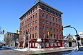
| Bank of Toronto |
456 Main Street
Winnipeg MB |
49°53′51″N 97°08′22″W / 49.8974°N 97.1394°W / 49.8974; -97.1394 (Bank of Toronto) |
Winnipeg municipality (7338) |
|
Upload Photo |
| W.F. Alloway Building |
179 McDermot Avenue
Winnipeg MB |
49°53′51″N 97°08′16″W / 49.8974°N 97.1378°W / 49.8974; -97.1378 (W.F. Alloway Building) |
Winnipeg municipality (7339) |
|
Upload Photo |
| Northern Electric Building |
140 Bannatyne Avenue
Winnipeg MB |
49°53′50″N 97°08′11″W / 49.8973°N 97.1365°W / 49.8973; -97.1365 (Northern Electric Building) |
Winnipeg municipality (7340) |
|
Upload Photo |
| Edmonton Street Duplex |
368-370 Edmonton Street
Winnipeg MB |
49°53′42″N 97°08′56″W / 49.8949°N 97.1489°W / 49.8949; -97.1489 (Edmonton Street Duplex) |
Winnipeg municipality (7344) |
|
Upload Photo |
| Alloway and Champion Bank |
667 Main Street
Winnipeg MB |
49°54′11″N 97°08′06″W / 49.9031°N 97.1349°W / 49.9031; -97.1349 (Alloway and Champion Bank) |
Winnipeg municipality (7346) |
|
Upload Photo |
| Pantages Playhouse Theatre |
180 Market Avenue
Winnipeg MB |
49°53′56″N 97°08′16″W / 49.8989°N 97.1379°W / 49.8989; -97.1379 (Pantages Playhouse Theatre) |
Federal (12956),
Manitoba (7397),
Winnipeg municipality (7367) |
|

More images |
| Canadian Pacific Railway Station (Winnipeg) National Historic Site of Canada |
181 Higgins Avenue
Winnipeg MB |
49°54′16″N 97°07′54″W / 49.9045°N 97.1318°W / 49.9045; -97.1318 (Canadian Pacific Railway Station (Winnipeg) National Historic Site of Canada) |
Federal (7402, (6467),
Manitoba (6345),
Winnipeg municipality (6343) |
|

More images |
| Confederation Building National Historic Site of Canada |
457 Main Street
Winnipeg MB |
49°53′54″N 97°08′20″W / 49.8984°N 97.1388°W / 49.8984; -97.1388 (Confederation Building National Historic Site of Canada) |
Federal (7599),
Winnipeg municipality (5950) |
|

More images |
| Galpern Building |
165 McDermot Avenue
Winnipeg MB |
49°53′50″N 97°08′14″W / 49.8972°N 97.1371°W / 49.8972; -97.1371 (Galpern Building) |
Winnipeg municipality (7719) |
|
Upload Photo |
| Warwick Apartments |
366 Qu'Appelle Avenue
Winnipeg MB |
49°53′43″N 97°08′52″W / 49.8954°N 97.1478°W / 49.8954; -97.1478 (Warwick Apartments) |
Winnipeg municipality (7727) |
|
Upload Photo |
| New Hargrave Building |
361-365 Hargrave Street
Winnipeg MB |
49°53′43″N 97°08′43″W / 49.8954°N 97.1454°W / 49.8954; -97.1454 (New Hargrave Building) |
Winnipeg municipality (7870) |
|
Upload Photo |
| Odd Fellows Temple Facade |
Winnipeg MB |
49°53′34″N 97°08′56″W / 49.8927°N 97.1488°W / 49.8927; -97.1488 (Odd Fellows Temple Facade) |
Winnipeg municipality (8193) |
|
 |
| Wesley Hall |
515 Portage Avenue
Winnipeg MB |
49°53′27″N 97°09′12″W / 49.8908°N 97.1533°W / 49.8908; -97.1533 (Wesley Hall) |
Winnipeg municipality (8224) |
|
 |
| Ukrainian Cultural Centre |
184 Alexander Avenue
Winnipeg MB |
49°54′04″N 97°08′09″W / 49.9012°N 97.1359°W / 49.9012; -97.1359 (Ukrainian Cultural Centre) |
Winnipeg municipality (8226) |
|
 |
| Miller and Richard Type Foundry Building |
121/123 Princess Street
Winnipeg MB |
49°53′56″N 97°08′29″W / 49.8989°N 97.1414°W / 49.8989; -97.1414 (Miller and Richard Type Foundry Building) |
Winnipeg municipality (8236) |
|
Upload Photo |
| MacKenzie Block |
141 Bannatyne Avenue
Winnipeg MB |
49°53′52″N 97°08′10″W / 49.8977°N 97.136°W / 49.8977; -97.136 (MacKenzie Block) |
Winnipeg municipality (8244) |
|
Upload Photo |
| Ashdown Store |
211 Bannatyne Avenue
Winnipeg MB |
49°53′53″N 97°08′23″W / 49.8981°N 97.1397°W / 49.8981; -97.1397 (Ashdown Store) |
Winnipeg municipality (8390) |
|
 |
| Massey Building |
294 William Avenue
Winnipeg MB |
49°53′57″N 97°08′28″W / 49.8993°N 97.1411°W / 49.8993; -97.1411 (Massey Building) |
Winnipeg municipality (8484) |
|
Upload Photo |
| Bedford Building |
281 McDermot Avenue
Winnipeg MB |
49°53′52″N 97°08′30″W / 49.8977°N 97.1418°W / 49.8977; -97.1418 (Bedford Building) |
Winnipeg municipality (8492) |
|
Upload Photo |
| Hammond Building |
63 Albert Street
Winnipeg MB |
49°53′48″N 97°08′24″W / 49.8966°N 97.14°W / 49.8966; -97.14 (Hammond Building) |
Winnipeg municipality (8574) |
|
Upload Photo |
| Public Press Building |
290 Vaughan Street
Winnipeg MB |
49°53′32″N 97°09′01″W / 49.8921°N 97.1504°W / 49.8921; -97.1504 (Public Press Building) |
Winnipeg municipality (8606) |
|
Upload Photo |
| Sherbrook Pool |
381 Sherbrook Street
Winnipeg MB |
49°53′24″N 97°09′31″W / 49.89°N 97.1585°W / 49.89; -97.1585 (Sherbrook Pool) |
Winnipeg municipality (8643) |
|

More images |
| Union Bank Building (Royal Bank Building) |
504 Main Street
Winnipeg MB |
49°53′56″N 97°08′23″W / 49.8989°N 97.1396°W / 49.8989; -97.1396 (Union Bank Building (Royal Bank Building)) |
Winnipeg municipality (8645) |
|
|
| Imperial Bank of Canada |
441 Main Street
Winnipeg MB |
49°53′53″N 97°08′19″W / 49.8981°N 97.1386°W / 49.8981; -97.1386 (Imperial Bank of Canada) |
Winnipeg municipality (8660) |
|
Upload Photo |
| Bank of British North America |
436 Main Street
Winnipeg MB |
49°53′48″N 97°08′21″W / 49.8967°N 97.1393°W / 49.8967; -97.1393 (Bank of British North America) |
Winnipeg municipality (8663) |
|
Upload Photo |
| Union Bank Building Annex |
500 Main Street
Winnipeg MB |
49°53′55″N 97°08′22″W / 49.8987°N 97.1395°W / 49.8987; -97.1395 (Union Bank Building Annex) |
Winnipeg municipality (8665) |
|

More images |
| The Old Market Autonomous Zone |
91 Albert Street
Winnipeg MB |
49°53′51″N 97°08′24″W / 49.8975°N 97.1399°W / 49.8975; -97.1399 (The Old Market Autonomous Zone) |
Winnipeg municipality (8668) |
|
 |
| Marlborough Hotel |
331 Smith Street
Winnipeg MB |
49°53′42″N 97°08′33″W / 49.895°N 97.1426°W / 49.895; -97.1426 (Marlborough Hotel) |
Winnipeg municipality (8673) |
|
Upload Photo |
| Albert Block |
86 Albert Street
Winnipeg MB |
49°53′51″N 97°08′26″W / 49.8974°N 97.1405°W / 49.8974; -97.1405 (Albert Block) |
Winnipeg municipality (8701) |
|
 |
| Gregg Building |
52 Albert Street
Winnipeg MB |
49°53′47″N 97°08′26″W / 49.8963°N 97.1406°W / 49.8963; -97.1406 (Gregg Building) |
Winnipeg municipality (8741) |
|
Upload Photo |
| Swiss Building |
137 Bannatyne Avenue
Winnipeg MB |
49°53′51″N 97°08′09″W / 49.8976°N 97.1358°W / 49.8976; -97.1358 (Swiss Building) |
Winnipeg municipality (8742) |
|
Upload Photo |
| Ambassador Apartments |
379 Hargrave Street
Winnipeg MB |
49°53′45″N 97°08′45″W / 49.8959°N 97.1458°W / 49.8959; -97.1458 (Ambassador Apartments) |
Winnipeg municipality (8743) |
|
Upload Photo |
| T.W. Taylor Building |
177 McDermot Avenue
Winnipeg MB |
49°53′56″N 97°08′15″W / 49.8989°N 97.1376°W / 49.8989; -97.1376 (T.W. Taylor Building) |
Winnipeg municipality (8800) |
|
Upload Photo |
| Raleigh Apartments |
340 Vaughan Street
Winnipeg MB |
49°53′36″N 97°09′03″W / 49.8932°N 97.1509°W / 49.8932; -97.1509 (Raleigh Apartments) |
Winnipeg municipality (8808) |
|
More images |
| Dominion Bank Building |
678 Main Street
Winnipeg MB |
49°54′15″N 97°08′07″W / 49.9043°N 97.1352°W / 49.9043; -97.1352 (Dominion Bank Building) |
Winnipeg municipality (8810) |
|
 |
| Portage Village Inn |
311 Portage Avenue
Winnipeg MB |
49°53′38″N 97°08′38″W / 49.8938°N 97.1438°W / 49.8938; -97.1438 (Portage Village Inn) |
Winnipeg municipality (9027) |
|
Upload Photo |
| Mitchell-Copp Building |
315 Portage Avenue
Winnipeg MB |
49°53′38″N 97°08′39″W / 49.8938°N 97.1442°W / 49.8938; -97.1442 (Mitchell-Copp Building) |
Winnipeg municipality (9029) |
|
Upload Photo |
| Chamber of Commerce Building |
177 Lombard Avenue
Winnipeg MB |
49°53′47″N 97°08′15″W / 49.8965°N 97.1375°W / 49.8965; -97.1375 (Chamber of Commerce Building) |
Manitoba (9415),
Winnipeg municipality (9401) |
|
 |
| Kilgour Block |
181 Bannatyne Avenue
Winnipeg MB |
49°53′54″N 97°08′16″W / 49.8982°N 97.1379°W / 49.8982; -97.1379 (Kilgour Block) |
Winnipeg municipality (9420) |
|
Upload Photo |
| Dingwall Building |
62 Albert Street
Winnipeg MB |
49°53′48″N 97°08′26″W / 49.8966°N 97.1406°W / 49.8966; -97.1406 (Dingwall Building) |
Winnipeg municipality (9442) |
|
Upload Photo |
| Early Skyscrapers in Winnipeg National Historic Site of Canada |
191 Lombard Ave.; 395 Main St.; 457 Main Street
Winnipeg MB |
49°53′47″N 97°08′18″W / 49.8964°N 97.1383°W / 49.8964; -97.1383 (Early Skyscrapers in Winnipeg National Historic Site of Canada) |
Federal (10702) |
|

More images |
| Robinson, Little and Company Building |
54 Arthur Street
Winnipeg MB |
49°53′48″N 97°08′30″W / 49.8967°N 97.1418°W / 49.8967; -97.1418 (Robinson, Little and Company Building) |
Winnipeg municipality (11522) |
|
Upload Photo |
| R.J. Whitla and Company Building |
70 Arthur Street
Winnipeg MB |
49°53′49″N 97°08′30″W / 49.897°N 97.1416°W / 49.897; -97.1416 (R.J. Whitla and Company Building) |
Winnipeg municipality (11523) |
|
Upload Photo |
| Merchants Building |
250 McDermot Avenue
Winnipeg MB |
49°53′49″N 97°08′27″W / 49.8969°N 97.1409°W / 49.8969; -97.1409 (Merchants Building) |
Winnipeg municipality (11536) |
|
Upload Photo |
| Salvation Army Citadel |
221 Rupert Avenue
Winnipeg MB |
49°54′05″N 97°08′18″W / 49.9013°N 97.1383°W / 49.9013; -97.1383 (Salvation Army Citadel) |
Winnipeg municipality (12049) |
|
Upload Photo |
| Birt's Saddlery |
468 Main Street
Winnipeg MB |
49°53′52″N 97°08′22″W / 49.8977°N 97.1395°W / 49.8977; -97.1395 (Birt's Saddlery) |
Winnipeg municipality (12050) |
|
 |
| Great West Saddlery Building |
113 Market Avenue
Winnipeg MB |
49°53′54″N 97°08′05″W / 49.8984°N 97.1347°W / 49.8984; -97.1347 (Great West Saddlery Building) |
Winnipeg municipality (12051) |
|

More images |
| Electric Railway Chambers |
213 Notre Dame Avenue
Winnipeg MB |
49°53′44″N 97°08′25″W / 49.8956°N 97.1403°W / 49.8956; -97.1403 (Electric Railway Chambers) |
Winnipeg municipality (12052) |
|

More images |
| Great West Saddlery Warehouse |
112-114 Market Avenue
Winnipeg MB |
49°53′53″N 97°08′06″W / 49.898°N 97.1349°W / 49.898; -97.1349 (Great West Saddlery Warehouse) |
Winnipeg municipality (12053) |
|
 |
| Chatfield Distributors Building |
168 Bannatyne Avenue
Winnipeg MB |
49°53′51″N 97°08′15″W / 49.8976°N 97.1375°W / 49.8976; -97.1375 (Chatfield Distributors Building) |
Winnipeg municipality (12054) |
|
Upload Photo |
| Royal Manitoba Theatre Centre National Historic Site of Canada |
174 Market Avenue
Winnipeg MB |
49°53′55″N 97°08′12″W / 49.89850°N 97.13674°W / 49.89850; -97.13674 (Manitoba Theatre Centre National Historic Site of Canada) |
Federal (14667) |
|
More images |
| Fort Garry Hotel National Historic Site of Canada |
222 Broadway Avenue
Winnipeg MB |
49°53′17″N 97°08′13″W / 49.888°N 97.1369°W / 49.888; -97.1369 (Fort Garry Hotel National Historic Site of Canada) |
Federal (1190),
Manitoba (5395),
Winnipeg municipality (5383) |
|

More images |
| Birks Building |
276 Portage Avenue
Winnipeg MB |
49°53′38″N 97°08′30″W / 49.894°N 97.1418°W / 49.894; -97.1418 (Birks Building) |
Winnipeg municipality (1535) |
|

More images |
| Casa Loma Building |
644 Portage Avenue
Winnipeg MB |
49°53′18″N 97°09′31″W / 49.8882°N 97.1586°W / 49.8882; -97.1586 (Casa Loma Building) |
Winnipeg municipality (1561) |
|
Upload Photo |
| Oldfield, Kirby and Gardner Building |
234 Portage Avenue
Winnipeg MB |
49°53′41″N 97°08′24″W / 49.8946°N 97.14°W / 49.8946; -97.14 (Oldfield, Kirby and Gardner Building) |
Winnipeg municipality (2097) |
|
 |
| Metropolitan Theatre National Historic Site of Canada |
291 Donald Street
Winnipeg MB |
49°53′36″N 97°08′35″W / 49.8934°N 97.1431°W / 49.8934; -97.1431 (Metropolitan Theatre National Historic Site of Canada) |
Federal (3110),
Winnipeg municipality (7725) |
|

More images |
| Dalnavert National Historic Site of Canada |
61 Carlton Street
Winnipeg MB |
49°53′11″N 97°08′33″W / 49.8865°N 97.1424°W / 49.8865; -97.1424 (Dalnavert National Historic Site of Canada) |
Federal (3999),
Manitoba (3995),
Winnipeg municipality (8120) |
|
More images |
| The Forks National Historic Site of Canada |
45 Forks Market Road
Winnipeg MB |
49°53′19″N 97°07′39″W / 49.8885°N 97.1276°W / 49.8885; -97.1276 (The Forks National Historic Site of Canada) |
Federal (4488) |
|
 |
| Northern Pacific and Manitoba Railway Repair Shop |
45 Forks Market Road
Winnipeg MB |
49°53′15″N 97°07′41″W / 49.8876°N 97.128°W / 49.8876; -97.128 (Northern Pacific and Manitoba Railway Repair Shop) |
Manitoba (4568) |
|
 |
| North West Commercial Travellers' Association Building |
291 Garry Street
Winnipeg MB |
49°53′38″N 97°08′25″W / 49.8938°N 97.1402°W / 49.8938; -97.1402 (North West Commercial Travellers' Association Building) |
Winnipeg municipality (5765) |
|
 |
| Carlton Building |
354 Portage Avenue
Winnipeg MB |
49°53′33″N 97°08′43″W / 49.8925°N 97.1454°W / 49.8925; -97.1454 (Carlton Building) |
Winnipeg municipality (6168) |
|
Upload Photo |
| Young United Church Tower |
212 Furby Street
Winnipeg MB |
49°53′08″N 97°09′29″W / 49.8856°N 97.158°W / 49.8856; -97.158 (Young United Church Tower) |
Winnipeg municipality (6657) |
|
 |
| Canada Permanent Building |
298 Garry Street
Winnipeg MB |
49°53′38″N 97°08′27″W / 49.8938°N 97.1409°W / 49.8938; -97.1409 (Canada Permanent Building) |
Winnipeg municipality (6661) |
|
 |
| Gates at East Gate, West Gate, Middle Gate |
Cornish Avenue
Winnipeg MB |
49°52′44″N 97°09′30″W / 49.8788°N 97.1583°W / 49.8788; -97.1583 (Gates at East Gate, West Gate, Middle Gate) |
Winnipeg municipality (6828) |
|
Upload Photo |
| Garry Block |
290 Garry Street
Winnipeg MB |
49°53′37″N 97°08′28″W / 49.8937°N 97.141°W / 49.8937; -97.141 (Garry Block) |
Winnipeg municipality (6835) |
|
Upload Photo |
| Ralph Connor House |
54 West Gate
Winnipeg MB |
49°53′55″N 97°08′12″W / 49.89850°N 97.13674°W / 49.89850; -97.13674 (Ralph Connor House) |
Federal (15003),
Manitoba (6289),
Winnipeg municipality (6876) |
|

More images |
| Cornish Library |
20 West Gate
Winnipeg MB |
49°52′42″N 97°09′36″W / 49.8784°N 97.1599°W / 49.8784; -97.1599 (Cornish Library) |
Winnipeg municipality (6885) |
|
 |
| Upper Fort Garry Gate |
130 Main Street
Winnipeg MB |
49°53′17″N 97°08′07″W / 49.888°N 97.1353°W / 49.888; -97.1353 (Upper Fort Garry Gate) |
Winnipeg municipality (6939) |
|

More images |
| Bank of Hamilton |
395 Main Street
Winnipeg MB |
49°53′35″N 97°08′20″W / 49.893°N 97.1388°W / 49.893; -97.1388 (Bank of Hamilton) |
Winnipeg municipality (7345) |
|
 |
| Kerr House |
351 Assiniboine Avenue
Winnipeg MB |
49°53′06″N 97°08′23″W / 49.885°N 97.1397°W / 49.885; -97.1397 (Kerr House) |
Winnipeg municipality (7872) |
|
Upload Photo |
| Johnston Terminal Building |
45 Forks Market Road
Winnipeg MB |
49°53′14″N 97°07′47″W / 49.8872°N 97.1298°W / 49.8872; -97.1298 (Johnston Terminal Building) |
Winnipeg municipality (8195) |
|
 |
| Granite Curling Club |
22 Mostyn Place
Winnipeg MB |
49°52′57″N 97°09′02″W / 49.8826°N 97.1505°W / 49.8826; -97.1505 (Granite Curling Club) |
Winnipeg municipality (8215) |
|
More images |
| Glines House |
55 Hargrave Street
Winnipeg MB |
49°53′10″N 97°08′26″W / 49.886°N 97.1405°W / 49.886; -97.1405 (Glines House) |
Winnipeg municipality (8578) |
|
Upload Photo |
| H.E. Sharpe House |
56 Balmoral Street
Winnipeg MB |
49°52′59″N 97°09′11″W / 49.883°N 97.153°W / 49.883; -97.153 (H.E. Sharpe House) |
Winnipeg municipality (9416) |
|
Upload Photo |
| Princeton Apartments |
314 Broadway
Winnipeg MB |
49°53′14″N 97°08′27″W / 49.8871°N 97.1407°W / 49.8871; -97.1407 (Princeton Apartments) |
Winnipeg municipality (9421) |
|
Upload Photo |
| Winnipeg Law Courts National Historic Site of Canada |
391 Broadway Avenue
Winnipeg MB |
49°53′12″N 97°08′46″W / 49.8868°N 97.1462°W / 49.8868; -97.1462 (Winnipeg Law Courts National Historic Site of Canada) |
Federal (12789) |
|
More images |
| Holy Trinity Anglican Church National Historic Site of Canada |
269 Donald Street
Winnipeg MB |
49°53′33″N 97°08′32″W / 49.8925°N 97.1422°W / 49.8925; -97.1422 (Holy Trinity Anglican Church National Historic Site of Canada) |
Federal (12894),
Winnipeg municipality (11538) |
|

More images |
| Forts Rouge, Garry and Gibraltar National Historic Site of Canada |
Winnipeg MB |
49°53′17″N 97°08′07″W / 49.888°N 97.1354°W / 49.888; -97.1354 (Forts Rouge, Garry and Gibraltar National Historic Site of Canada) |
Federal (13312) |
|
 |
| St. Edward the Confessor Roman Catholic Church |
836 Arlington Street
Winnipeg MB |
49°54′09″N 97°10′07″W / 49.9025°N 97.1686°W / 49.9025; -97.1686 (St. Edward the Confessor Roman Catholic Church) |
Winnipeg municipality (5394) |
|
Upload Photo |
| Principal Sparling School |
1150 Sherburn Street
Winnipeg MB |
49°54′16″N 97°10′30″W / 49.9044°N 97.1751°W / 49.9044; -97.1751 (Principal Sparling School) |
Winnipeg municipality (5400) |
|
Upload Photo |
| First Presbyterian Church |
61 Picardy Place
Winnipeg MB |
49°53′10″N 97°09′58″W / 49.886°N 97.166°W / 49.886; -97.166 (First Presbyterian Church) |
Manitoba (3856) |
|

More images |
| Trappist Monastery Guest House |
100 rue des Ruins de Monastere
Winnipeg MB |
49°53′55″N 97°08′12″W / 49.89850°N 97.13674°W / 49.89850; -97.13674 (Trappist Monastery Guest House) |
Manitoba (4164),
Winnipeg municipality (6858) |
|
 |
| Laura Secord School |
960 Wolseley Avenue
Winnipeg MB |
49°52′44″N 97°10′21″W / 49.8789°N 97.1725°W / 49.8789; -97.1725 (Laura Secord School) |
Winnipeg municipality (5370) |
|
Upload Photo |
| Rothesay Apartments |
828 Preston Avenue
Winnipeg MB |
49°53′02″N 97°10′04″W / 49.8838°N 97.1679°W / 49.8838; -97.1679 (Rothesay Apartments) |
Winnipeg municipality (6013) |
|

More images |
| Wolseley School |
511 Clifton Street
Winnipeg MB |
49°52′52″N 97°11′09″W / 49.8812°N 97.1857°W / 49.8812; -97.1857 (Wolseley School) |
Winnipeg municipality (6095) |
|
Upload Photo |
| Westminster United Church |
745 Westminster Avenue
Winnipeg MB |
49°52′56″N 97°09′42″W / 49.8822°N 97.1617°W / 49.8822; -97.1617 (Westminster United Church) |
Manitoba (8150),
Winnipeg municipality (7699) |
|
 |
| Moyse House |
838 Wolseley Avenue
Winnipeg MB |
49°52′44″N 97°09′58″W / 49.8789°N 97.1662°W / 49.8789; -97.1662 (Moyse House) |
Winnipeg municipality (8642) |
|
Upload Photo |
| Thelma Apartments |
272 Home Street
Winnipeg MB |
49°53′06″N 97°10′07″W / 49.8849°N 97.1686°W / 49.8849; -97.1686 (Thelma Apartments) |
Winnipeg municipality (8719) |
|
Upload Photo |
| Bellcrest Apartments |
72 Lenore Street
Winnipeg MB |
49°52′47″N 97°10′20″W / 49.8796°N 97.1722°W / 49.8796; -97.1722 (Bellcrest Apartments) |
Winnipeg municipality (9028) |
|
Upload Photo |
| Silver Heights Gates |
Mount Royal Road at Traill Avenue
Winnipeg MB |
49°52′37″N 97°14′44″W / 49.8769°N 97.2456°W / 49.8769; -97.2456 (Silver Heights Gates) |
Winnipeg municipality (6829) |
|
Upload Photo |
| Women's Tribute Memorial Lodge |
200 Woodlawn Street
Winnipeg MB |
49°52′39″N 97°14′05″W / 49.8775°N 97.2347°W / 49.8775; -97.2347 (Women's Tribute Memorial Lodge) |
Manitoba (8801),
Winnipeg municipality (8549) |
|
Upload Photo |
| William Brown House |
3180 Portage Avenue
Winnipeg MB |
49°52′50″N 97°17′18″W / 49.8805°N 97.2883°W / 49.8805; -97.2883 (William Brown House) |
Winnipeg municipality (8196) |
|
Upload Photo |
| Roslyn Court Apartments National Historic Site of Canada |
105 Roslyn Road / 40 Osborne Street
Winnipeg MB |
49°52′49″N 97°08′48″W / 49.8803°N 97.1467°W / 49.8803; -97.1467 (Roslyn Court Apartments National Historic Site of Canada) |
Federal (1159),
Winnipeg municipality (6910) |
|

More images |
| Congress Apartments |
300 River Avenue
Winnipeg MB |
49°52′52″N 97°08′25″W / 49.881°N 97.1402°W / 49.881; -97.1402 (Congress Apartments) |
Winnipeg municipality (5847) |
|
Upload Photo |
| St. Luke's Anglican Church |
130 Nassau Street
Winnipeg MB |
49°52′43″N 97°08′57″W / 49.8785°N 97.1492°W / 49.8785; -97.1492 (St. Luke's Anglican Church) |
Manitoba (7718) |
|
Upload Photo |
| Wardlow Apartments |
544 Wardlaw Avenue
Winnipeg MB |
49°52′31″N 97°08′52″W / 49.8754°N 97.1478°W / 49.8754; -97.1478 (Wardlow Apartments) |
Winnipeg municipality (7726) |
|
Upload Photo |
| Lilly Apartments |
6 Roslyn Road
Winnipeg MB |
49°52′52″N 97°08′33″W / 49.8811°N 97.1425°W / 49.8811; -97.1425 (Lilly Apartments) |
Winnipeg municipality (8129) |
|
Upload Photo |
| DeBary Apartments |
626 Wardlaw Avenue
Winnipeg MB |
49°52′29″N 97°08′59″W / 49.8747°N 97.1498°W / 49.8747; -97.1498 (DeBary Apartments) |
Winnipeg municipality (8221) |
|

More images |
| J.C. Falls House |
36 Roslyn Road
Winnipeg MB |
49°52′51″N 97°08′38″W / 49.8807°N 97.1438°W / 49.8807; -97.1438 (J.C. Falls House) |
Winnipeg municipality (8384) |
|
Upload Photo |
| Nanton Estate Gates |
229 Roslyn Road
Winnipeg MB |
49°52′46″N 97°09′08″W / 49.8794°N 97.1521°W / 49.8794; -97.1521 (Nanton Estate Gates) |
Winnipeg municipality (8461) |
|
Upload Photo |
| John C. Graham House |
137 Scott Street
Winnipeg MB |
49°52′45″N 97°08′29″W / 49.8791°N 97.1415°W / 49.8791; -97.1415 (John C. Graham House) |
Winnipeg municipality (8586) |
|
Upload Photo |
| Paterson Block |
54 Donald Street
Winnipeg MB |
49°53′10″N 97°08′23″W / 49.886°N 97.1398°W / 49.886; -97.1398 (Paterson Block) |
Winnipeg municipality (8806) |
|
Upload Photo |
| John Duncan McArthur House |
159 Mayfair Avenue
Winnipeg MB |
49°53′03″N 97°08′07″W / 49.8842°N 97.1354°W / 49.8842; -97.1354 (John Duncan McArthur House) |
Winnipeg municipality (11539) |
|
Upload Photo |
| Augustine United Church |
444 River Avenue
Winnipeg MB |
49°53′03″N 97°08′07″W / 49.8842°N 97.1354°W / 49.8842; -97.1354 (Augustine United Church) |
Winnipeg municipality (11817) |
|
Upload Photo |
| Anvers Apartments |
758 McMillan Avenue
Winnipeg MB |
49°52′15″N 97°09′18″W / 49.8709°N 97.1551°W / 49.8709; -97.1551 (Anvers Apartments) |
Winnipeg municipality (5589) |
|
Upload Photo |
| Earl Grey School |
340 Cockburn Street
Winnipeg MB |
49°52′03″N 97°09′03″W / 49.8675°N 97.1507°W / 49.8675; -97.1507 (Earl Grey School) |
Winnipeg municipality (6047) |
|
Upload Photo |
| Khartum Temple (J.H. Ashdown House) |
529 Wellington Crescent
Winnipeg MB |
49°52′36″N 97°09′41″W / 49.8766°N 97.1613°W / 49.8766; -97.1613 (Khartum Temple (J.H. Ashdown House)) |
Winnipeg municipality (6438) |
|

More images |
| R.R. Scott House |
29 Ruskin Row
Winnipeg MB |
49°52′27″N 97°09′47″W / 49.8741°N 97.1631°W / 49.8741; -97.1631 (R.R. Scott House) |
Winnipeg municipality (6886) |
|
Upload Photo |
| St. Michael and All Angels Anglican Church |
300 Hugo Street North
Winnipeg MB |
49°52′10″N 97°08′57″W / 49.8694°N 97.1493°W / 49.8694; -97.1493 (St. Michael and All Angels Anglican Church) |
Winnipeg municipality (7914) |
|
Upload Photo |
| Pasadena Apartments |
220 Hugo Street North
Winnipeg MB |
49°52′21″N 97°09′06″W / 49.8726°N 97.1518°W / 49.8726; -97.1518 (Pasadena Apartments) |
Winnipeg municipality (8381) |
|
Upload Photo |
| Fortune Residence |
393 Wellington Crescent
Winnipeg MB |
49°52′24″N 97°09′26″W / 49.8733°N 97.1572°W / 49.8733; -97.1572 (Fortune Residence) |
Winnipeg municipality (8700) |
|
Upload Photo |
| No. 12 Firehall |
1055 Dorchester Avenue
Winnipeg MB |
49°52′03″N 97°10′10″W / 49.8676°N 97.1695°W / 49.8676; -97.1695 (No. 12 Firehall) |
Winnipeg municipality (12055) |
|
Upload Photo |
| Uptown Theatre |
394 Academy Road
Winnipeg MB |
49°52′24″N 97°10′58″W / 49.8734°N 97.1828°W / 49.8734; -97.1828 (Uptown Theatre) |
Winnipeg municipality (6046) |
|
 |
| Julia Clark School |
615 Academy Road
Winnipeg MB |
49°52′31″N 97°11′59″W / 49.8754°N 97.1998°W / 49.8754; -97.1998 (Julia Clark School) |
Winnipeg municipality (8132) |
|
Upload Photo |
| Manitoba School for the Deaf |
500 Shaftesbury Blvd.
Winnipeg MB |
49°53′55″N 97°08′12″W / 49.89850°N 97.13674°W / 49.89850; -97.13674 (Manitoba School for the Deaf) |
Manitoba (5066) |
|
Upload Photo |
| Assiniboine Park Pavilion |
55 Pavilion Crescent
Winnipeg MB |
49°52′20″N 97°13′48″W / 49.8721°N 97.2301°W / 49.8721; -97.2301 (Assiniboine Park Pavilion) |
Winnipeg municipality (8233) |
|
More images |
| Caron House |
50 Cass Street
Winnipeg MB |
49°52′17″N 97°19′15″W / 49.8714°N 97.3207°W / 49.8714; -97.3207 (Caron House) |
Winnipeg municipality (8213) |
|
Upload Photo |
| La Chapelle de Notre-Dame-du-Bons-Secours |
80, rue Pierre
Winnipeg MB |
49°45′56″N 97°08′43″W / 49.7656°N 97.1452°W / 49.7656; -97.1452 (La Chapelle de Notre-Dame-du-Bons-Secours) |
Manitoba (3552) |
|
More images |
| Trappist Monastery Ruins |
Winnipeg MB |
49°45′24″N 97°09′14″W / 49.7567°N 97.1538°W / 49.7567; -97.1538 (Trappist Monastery Ruins) |
Manitoba (6856) |
|

More images |
| McDougall House |
3514 Pembina Highway
Winnipeg MB |
49°46′00″N 97°09′15″W / 49.7667°N 97.1542°W / 49.7667; -97.1542 (McDougall House) |
Winnipeg municipality (8058) |
|
Upload Photo |
| Pembina Highway House |
3514 Pembina Highway
Winnipeg MB |
49°46′00″N 97°09′14″W / 49.7667°N 97.1539°W / 49.7667; -97.1539 (Pembina Highway House) |
Winnipeg municipality (8059) |
|
More images |
| Customs Examining Warehouse |
Winnipeg MB |
49°53′49″N 97°08′10″W / 49.897°N 97.136°W / 49.897; -97.136 (Customs Examining Warehouse) |
Federal (3616) |
|
 |
| Postal Station "B" |
1048 Main Street
Winnipeg MB |
49°54′50″N 97°07′55″W / 49.914°N 97.132°W / 49.914; -97.132 (Postal Station "B") |
Federal (3618) |
|
Upload Photo |
| Stanley Knowles / Revenue Building |
391 York Avenue
Winnipeg MB |
49°53′18″N 97°08′44″W / 49.8884°N 97.1456°W / 49.8884; -97.1456 (Stanley Knowles / Revenue Building) |
Federal (4144) |
|
Upload Photo |
| Minto Armoury |
St. Matthews Street
Winnipeg MB |
49°53′27″N 97°10′44″W / 49.89078°N 97.17891°W / 49.89078; -97.17891 (Minto Armoury) |
Federal (4343) |
|
 |
| Building 84 |
17 Wing
Winnipeg MB |
49°53′35″N 97°14′56″W / 49.893°N 97.2489°W / 49.893; -97.2489 (Building 84) |
Federal (9584) |
|
Upload Photo |
| Building 86 |
Winnipeg MB |
49°53′39″N 97°14′57″W / 49.8941°N 97.2492°W / 49.8941; -97.2492 (Building 86) |
Federal (9621) |
|
Upload Photo |
| B8-Drill Hall (Korea Hall) |
1984 Grant Avenue
Winnipeg MB |
49°51′12″N 97°12′35″W / 49.8532°N 97.2096°W / 49.8532; -97.2096 (B8-Drill Hall (Korea Hall)) |
Federal (11496) |
|
Upload Photo |
| Hangar 16 |
16 East Street, CFB Winnipeg
Winnipeg MB |
49°53′44″N 97°14′46″W / 49.8956°N 97.2462°W / 49.8956; -97.2462 (Hangar 16) |
Federal (12960) |
|
Upload Photo |
| Hangar 11 |
11 East Street, CFB Winnipeg
Winnipeg MB |
49°53′44″N 97°14′46″W / 49.8956°N 97.2462°W / 49.8956; -97.2462 (Hangar 11) |
Federal (12963) |
|
Upload Photo |
| Hangar 10 |
10 East Street, CFB Winnipeg
Winnipeg MB |
49°53′51″N 97°14′56″W / 49.8975°N 97.2490°W / 49.8975; -97.2490 (Hangar 10) |
Federal (12961) |
|
Upload Photo |
| Commander's Residence |
205 Dromore Avenue
Winnipeg MB |
49°52′22″N 97°10′11″W / 49.8727°N 97.1697°W / 49.8727; -97.1697 (Commander's Residence) |
Federal (13394) |
|
Upload Photo |
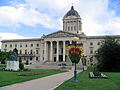
| Manitoba Legislative Building |
450 Broadway
Winnipeg MB |
49°53′55″N 97°08′12″W / 49.89850°N 97.13674°W / 49.89850; -97.13674 (Manitoba Legislative Building) |
Manitoba (15362) |
|
 |
| Smart Bag Company Building |
145 Pacific Avenue
Winnipeg MB |
49°54′03″N 97°08′04″W / 49.9007°N 97.1345°W / 49.9007; -97.1345 (Smart Bag Company Building) |
Winnipeg municipality (15838) |
|
Upload Photo |
| Battle of Seven Oaks National Historic Site of Canada |
Winnipeg MB |
49°55′53″N 97°07′15″W / 49.9314°N 97.1209°W / 49.9314; -97.1209 (Battle of Seven Oaks National Historic Site of Canada) |
Federal (16005) |
|

More images |
| Maison Gabrielle-Roy National Historic Site of Canada |
375 Deschambault Street
Winnipeg MB |
49°53′24″N 97°06′36″W / 49.8901°N 97.1101°W / 49.8901; -97.1101 (Maison Gabrielle-Roy National Historic Site of Canada) |
Federal (16342),
Manitoba (8694),
Winnipeg municipality (8698) |
|
More images |
| Hample Building |
271-273 1/2 Portage Avenue
Winnipeg MB |
49°53′41″N 97°08′32″W / 49.8946°N 97.1421°W / 49.8946; -97.1421 (Hample Building) |
Winnipeg municipality (16349) |
|
Upload Photo |
| Federal Building |
269 Main Street
Winnipeg MB |
49°53′37″N 97°08′14″W / 49.8935°N 97.1373°W / 49.8935; -97.1373 (Federal Building) |
Federal (2967) |
|
 |
| Knox United Church |
400 Edmonton Street
Winnipeg MB |
49°53′45″N 97°08′56″W / 49.8958°N 97.1490°W / 49.8958; -97.1490 (Knox United Church) |
Manitoba (4294) |
|
Upload Photo |
| Old St. James Anglican Church |
540 Tylehurst Street
Winnipeg MB |
49°52′48″N 97°11′58″W / 49.8799°N 97.1995°W / 49.8799; -97.1995 (Old St. James Anglican Church) |
Manitoba (4509) |
|
Upload Photo |
| Free Press Building |
300 Carlton Street
Winnipeg MB |
49°53′37″N 97°08′47″W / 49.8937°N 97.146486°W / 49.8937; -97.146486 (Free Press Building) |
Winnipeg municipality (5926) |
|
Upload Photo |
| Bank of Commerce |
389 Main Street
Winnipeg MB |
49°53′48″N 97°08′19″W / 49.8967°N 97.1386°W / 49.8967; -97.1386 (Bank of Commerce) |
Winnipeg municipality (5949) |
|
Upload Photo |
| Former Canadian Northern Railway Station |
Inkster Blvd. and Prairie Dog Trail
Winnipeg MB |
49°57′06″N 97°16′12″W / 49.9517°N 97.2700°W / 49.9517; -97.2700 (Former Canadian Northern Railway Station) |
Winnipeg municipality (6550) |
|
 |
| Calvary Temple Tower |
400 Hargrave Street
Winnipeg MB |
49°53′48″N 97°08′46″W / 49.8967°N 97.1461°W / 49.8967; -97.1461 (Calvary Temple Tower) |
Winnipeg municipality (6580) |
|
Upload Photo |
| Royal Bank of Canada Building |
460 Main Street
Winnipeg MB |
49°53′51″N 97°08′21″W / 49.8975°N 97.1391°W / 49.8975; -97.1391 (Royal Bank of Canada Building) |
Winnipeg municipality (6660) |
|
Upload Photo |
| Ross House Museum |
140 Meade Street North
Winnipeg MB |
49°54′25″N 97°07′45″W / 49.9069°N 97.1293°W / 49.9069; -97.1293 (Ross House Museum) |
Winnipeg municipality (6667) |
|
 |
| Marshall-Wells Building |
136 Market Avenue
Winnipeg MB |
49°53′55″N 97°08′09″W / 49.8985°N 97.1358°W / 49.8985; -97.1358 (Marshall-Wells Building) |
Winnipeg municipality (6837) |
|
Upload Photo |
| Carnegie Library |
380 Wiliam Avenue
Winnipeg MB |
49°54′03″N 97°08′42″W / 49.9007°N 97.145°W / 49.9007; -97.145 (Carnegie Library) |
Winnipeg municipality (6904) |
|
Upload Photo |
| Transcona Municipal Offices |
141 Regent Avenue West
Winnipeg MB |
49°53′42″N 97°00′19″W / 49.8951°N 97.0053°W / 49.8951; -97.0053 (Transcona Municipal Offices) |
Winnipeg municipality (7701) |
|
Upload Photo |
| J.B. Monk Residence |
134 West Gate
Winnipeg MB |
49°52′32″N 97°09′24″W / 49.8755°N 97.1568°W / 49.8755; -97.1568 (J.B. Monk Residence) |
Winnipeg municipality (7703) |
|
Upload Photo |
| Aikins House |
630 Westminster Avenue
Winnipeg MB |
49°52′54″N 97°09′22″W / 49.8817°N 97.1561°W / 49.8817; -97.1561 (Aikins House) |
Winnipeg municipality (7705) |
|
Upload Photo |
| Bank of Montreal |
426 Portage Avenue
Winnipeg MB |
49°53′29″N 97°08′56″W / 49.8915°N 97.1490°W / 49.8915; -97.1490 (Bank of Montreal) |
Winnipeg municipality (7916) |
|
Upload Photo |
| Sir Sam Steele School |
15 Chester Street
Winnipeg MB |
49°54′07″N 97°05′13″W / 49.9020°N 97.0869°W / 49.9020; -97.0869 (Sir Sam Steele School) |
Winnipeg municipality (7916) |
|
Upload Photo |
| Macdonald Shoe Store |
490 Main Street
Winnipeg MB |
49°53′52″N 97°08′21″W / 49.8978°N 97.1392°W / 49.8978; -97.1392 (Macdonald Shoe Store) |
Winnipeg municipality (8454) |
|
Upload Photo |
| Bate Building |
221 McDermot Avenue
Winnipeg MB |
49°53′50″N 97°08′24″W / 49.8971°N 97.1401°W / 49.8971; -97.1401 (Bate Building) |
Winnipeg municipality (8491) |
|
Upload Photo |
| Bank of Montreal |
335 Main Street
Winnipeg MB |
49°53′42″N 97°08′17″W / 49.8950°N 97.1381°W / 49.8950; -97.1381 (Bank of Montreal) |
Winnipeg municipality (8611) |
|
Upload Photo |
| Klinic Building |
545 Broadway
Winnipeg MB |
49°53′08″N 97°09′06″W / 49.8855°N 97.1517°W / 49.8855; -97.1517 (Klinic Building) |
Winnipeg municipality (8667) |
|
Upload Photo |
| J.W. Harris House |
26 Edmonton Street
Winnipeg MB |
49°53′05″N 97°08′34″W / 49.8846°N 97.1429°W / 49.8846; -97.1429 (J.W. Harris House) |
Winnipeg municipality (8702) |
|
Upload Photo |
| Merchants Bank |
1386 Main Street
Winnipeg MB |
49°55′30″N 97°07′32″W / 49.9250°N 97.1256°W / 49.9250; -97.1256 (Merchants Bank) |
Winnipeg municipality (8740) |
|
Upload Photo |
| Travellers Building |
283 Bannatyne Avenue
Winnipeg MB |
49°53′54″N 97°08′29″W / 49.8984°N 97.1414°W / 49.8984; -97.1414 (Travellers Building) |
Winnipeg municipality (8744) |
|
 |
| McGregor Street Armoury |
515 Machray Avenue
Winnipeg MB |
49°55′38″N 97°08′22″W / 49.9273°N 97.1395°W / 49.9273; -97.1395 (McGregor Street Armoury) |
Federal (9558) |
|
Upload Photo |
| Building 21 |
CFB Winnipeg
Winnipeg MB |
49°53′31″N 97°14′11″W / 49.8919°N 97.2364°W / 49.8919; -97.2364 (Building 21) |
Federal (9558) |
|
Upload Photo |


.jpg)

.jpg)

.jpg)


.jpg)
.jpg)


.jpg)


.jpg)


.jpg)


.jpg)
.jpg)

.jpg)


_(16244235550).jpg)
_(9447472976).jpg)

