Literberry, Illinois
From Wikipedia, the free encyclopedia
Literberry, Illinois | |
|---|---|
 Literberry  Literberry | |
| Coordinates: 39°51′15″N 90°11′58″W / 39.85417°N 90.19944°W | |
| Country | United States |
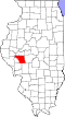
| State | Illinois |
| County | Morgan |
| Area | |
• Total | 0.81 sq mi (2.10 km2) |
| • Land | 0.81 sq mi (2.10 km2) |
| • Water | 0 sq mi (0.00 km2) |
| Elevation | 600 ft (180 m) |
| Population | |
• Total | 71 |
| • Density | 87.5/sq mi (33.78/km2) |
| Time zone | UTC-6 (Central (CST)) |
| • Summer (DST) | UTC-5 (CDT) |
| ZIP code | 62660 |
| Area code | 217 |
| GNIS feature ID | 2804094[2] |
Literberry is an unincorporated community and census-designated place (CDP) in Morgan County, Illinois, United States. It is 8 miles (13 km) north of Jacksonville, the county seat. Literberry formerly had a post office with ZIP code 62660.[4] The community became a CDP prior to the 2020 census, at which time it had a population of 71.[3]
An F4 tornado devastated Literberry on May 18, 1883, killing 12 people.[5]