Lucerne, Kansas
From Wikipedia, the free encyclopedia
Lucerne, Kansas | |
|---|---|
 | |
 Lucerne  Lucerne | |
| Coordinates: 39°29′48″N 100°12′01″W / 39.49667°N 100.20028°W | |
| Country | United States |
| State | Kansas |
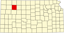
| County | Sheridan |
| Township | Adell |
| Elevation | 2,648 ft (807 m) |
| Population | |
• Total | 0 |
| Time zone | UTC-6 (CST) |
| • Summer (DST) | UTC-5 (CDT) |
| Area code | 785 |
| GNIS ID | 484550[1] |
Lucerne is a ghost town in Adell Township, Sheridan County, Kansas, United States. It is approximately 18 miles northeast of the county seat of Hoxie.
The town had a post office from 1880 until 1943. As of 2010, the remains of the town included a cemetery, stone foundation, and a partial wooden sign that used to announce the town's name.[2] As of the 2010 census, the entirety of Adell Township had a population of only 12.[3]
According to a 1912 reference work on Kansas, the town at that time held a population of 50, a general store, a hotel, a money order post office, and a daily stagecoach to the town of Jennings.[4]