Ludwigsstadt
From Wikipedia, the free encyclopedia
Ludwigsstadt | |
|---|---|
 DB train passing Trogenbach viaduct | |
 Coat of arms | |
Location of Ludwigsstadt within Kronach district 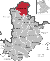 | |
 Ludwigsstadt  Ludwigsstadt | |
| Coordinates: 50°29′09″N 11°23′15″E / 50.48583°N 11.38750°E | |
| Country | Germany |
| State | Bavaria |
| Admin. region | Oberfranken |
| District | Kronach |
| Subdivisions | 5 Ortsteile |
| Government | |
| • Mayor (2020–26) | Timo Ehrhardt[1] (SPD) |
| Area | |
• Total | 58.72 km2 (22.67 sq mi) |
| Elevation | 446 m (1,463 ft) |
| Population (2023-12-31)[2] | |
• Total | 3,315 |
| • Density | 56/km2 (150/sq mi) |
| Time zone | UTC+01:00 (CET) |
| • Summer (DST) | UTC+02:00 (CEST) |
| Postal codes | 96337 |
| Dialling codes | 09263 |
| Vehicle registration | KC |
| Website | www.ludwigsstadt.de |
Ludwigsstadt is a town in the district of Kronach, in the Upper Franconian region of Bavaria, Germany.
It is situated in the valley of the Loquitz River, a tributary of the Saale, in the Thuringian-Franconian Highlands of the Thuringian Slate Mountains and the Franconian Forest mountain ranges. Located 28 kilometres (17 mi) north of Kronach, the Bavarian border with the state of Thuringia runs about 3 km (1.9 mi) north of the town centre, with Thuringian Saalfeld in a distance of c. 18 km (11 mi) down the Loquitz. Ludwigsstadt is the only municipality of the State of Bavaria located north of the Rennsteig ridge.
It is the second-northernmost town in Bavaria, behind Fladungen.


