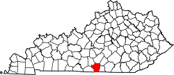
Marrowbone, Cumberland County, Kentucky
From Wikipedia, the free encyclopedia
Marrowbone, Kentucky | |
|---|---|
 Modern Woodmen lodge building on Kentucky Route 90 | |
  Marrowbone Location within the state of Kentucky  Marrowbone Marrowbone (the United States) | |
| Coordinates: 36°49′39″N 85°30′24″W / 36.82750°N 85.50667°W | |
| Country | United States |
| State | Kentucky |
| County | Cumberland |
| Area | |
• Total | 1.29 sq mi (3.34 km2) |
| • Land | 1.27 sq mi (3.30 km2) |
| • Water | 0.015 sq mi (0.04 km2) |
| Elevation | 643 ft (196 m) |
| Population (2020) | |
• Total | 147 |
| • Density | 115.4/sq mi (44.54/km2) |
| Time zone | UTC-6 (Central (CST)) |
| • Summer (DST) | UTC-5 (CDT) |
| ZIP codes | 42759 |
| FIPS code | 21-50124 |
| GNIS feature ID | 497558 |
Marrowbone is a census-designated place in Cumberland County, Kentucky, United States. As of the 2010 census it had a population of 217.[2] It has a post office, with the ZIP code of 42759.[3]
The Marrowbone Historic District, which includes three properties, is listed on the National Register of Historic Places.