Mary Hill, Iowa
From Wikipedia, the free encyclopedia
Mary Hill, Iowa | |
|---|---|
 Mary Hill, Iowa | |
| Coordinates: 42°44′08″N 95°41′19″W / 42.73556°N 95.68861°W | |
| Country | United States |
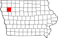
| State | Iowa |
| County | Cherokee |
| Elevation | 1,381 ft (421 m) |
| Time zone | UTC-6 (Central (CST)) |
| • Summer (DST) | UTC-5 (CDT) |
| Area code | 712 |
| GNIS feature ID | 464644[1] |
Mary Hill is an unincorporated community in Rock and Sheridan townships, Cherokee County, Iowa, United States.[1] Mary Hill is located along County Highway L48, 7 miles (11 km) west of Cherokee.[2]