McGee Creek, California
From Wikipedia, the free encyclopedia
McGee Creek, California | |
|---|---|
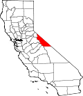
 Location in Mono County and the state of California | |
 McGee Creek  McGee Creek | |
| Coordinates: 37°34′22″N 118°47′28″W / 37.57278°N 118.79111°W | |
| Country | United States |
| State | California |
| County | Mono |
| Area | |
• Total | 4.01 sq mi (10.38 km2) |
| • Land | 4.01 sq mi (10.38 km2) |
| • Water | 0 sq mi (0 km2) |
| Elevation | 7,701 ft (2,347 m) |
| Population (2020)[3] | |
• Total | 45 |
| • Density | 11/sq mi (4.3/km2) |
| Time zone | UTC-8 (Pacific (PST)) |
| • Summer (DST) | UTC-7 (PDT) |
| ZIP Code | 93546 (Mammoth Lakes) |
| GNIS feature ID | 2583068[2] |
McGee Creek is an unincorporated community and census-designated place (CDP) in Mono County, California, United States. The community as of the 2020 census the population was 45.[3]
McGee Creek is in southwestern Mono County, sitting at the eastern base of the Sierra Nevada. U.S. Route 395 forms the northeast border of the community, leading northwest 12 miles (19 km) to Mammoth Lakes and southeast 30 miles (48 km) to Bishop. The CDP is named for McGee Creek, which flows out of the Sierra Nevada having risen at the McGee Lakes northeast of Red and White Mountain. McGee Creek Road climbs southwest up the creek valley, ending in 3 miles (5 km) at a trailhead within Inyo National Forest.
According to the United States Census Bureau, the McGee Creek CDP covers an area of 4.0 square miles (10 km2), all of it recorded as land.[1]