Meganisi
Greek island in the Ionian Sea
From Wikipedia, the free encyclopedia
Meganisi (Greek: Μεγανήσι, literally "big island") is a Greek island and municipality immediately to the east-southeast of the island of Lefkada. The municipality includes the offshore islands of Skorpios (pop. 2 persons) and Sparti. The municipality has an area of 22.356 km2.[2]

Meganisi
Μεγανήσι | |
|---|---|
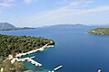
Vathy Harbor | |
 | |
 Meganisi | |
| Coordinates: 38°40′N 20°47′E | |
| Country | Greece |
| Administrative region | Ionian Islands |
| Regional unit | Lefkada |
| Seat | Katomeri |
| Area | |
• Municipality | 22.356 km2 (8.632 sq mi) |
| Highest elevation | 309 m (1,014 ft) |
| Lowest elevation | 0 m (0 ft) |
| Population (2021)[1] | |
• Municipality | 926 |
| • Density | 41.4/km2 (107/sq mi) |
| Time zone | UTC+2 (EET) |
| • Summer (DST) | UTC+3 (EEST) |
| Postal code | 310 83 |
| Area code | 26450 |
| Vehicle registration | EY |
| Website | meganisi.gov.gr |
The island has three villages: the central village of Katomeri and the ports of Vathy and Spartochori. There is also a harbour at Atheni Bay used mainly by fishing boats. Meganisi is connected with Lefkada by a car ferry service from Vathy and Spartochori. Meganisi has a school, a lyceum (middle school), an ATM, churches and a few squares (plateies). The island has no secondary school, so pupils attend the nearby school in Nydri, on Lefkada.
Some researchers, including Wilhelm Dörpfeld, believe that Meganisi was the Homeric island of Krocylea, which was part of Odysseus' kingdom.
Municipality
Historical population
| Year | Island population |
|---|---|
| 1981 | 1,149 |
| 1991 | 1,246 |
| 2001 | 1,092 |
| 2011 | 1,041 |
| 2021 | 926 |
Gallery
 Spilia Port
 Fanari Beach
 Atherinos Port


