Melville, North Dakota
From Wikipedia, the free encyclopedia
Melville, North Dakota | |
|---|---|
 Melville  Melville | |
| Coordinates: 47°20′05″N 99°02′08″W / 47.33472°N 99.03556°W | |
| Country | United States |
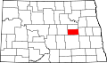
| State | North Dakota |
| County | Foster |
| Elevation | 1,604 ft (489 m) |
| Time zone | UTC-6 (Central (CST)) |
| • Summer (DST) | UTC-5 (CDT) |
| Area code | 701 |
| GNIS feature ID | 1030192[1] |
Melville is an unincorporated community in Foster County, North Dakota, United States. Melville is located along U.S. routes 52 and 281 and the Red River Valley and Western Railroad, 9 miles (14 km) south-southeast of Carrington.[2] Melville was originally named Newport after Northern Pacific Railway treasurer R. M. Newport; its name was changed to Melville for landowner Melville D. Carrington.[1]