Middle Road Covered Bridge
From Wikipedia, the free encyclopedia
LocaleAshtabula County, Ohio, United States
Designsingle span, Howe truss
Total length136 feet (41.5 m)
Middle Road Bridge | |
|---|---|
_Covered_Bridge_1.jpg) | |
| Coordinates | 41°54′07″N 80°32′49″W / 41.90194°N 80.54694°W |
| Locale | Ashtabula County, Ohio, United States |
| Characteristics | |
| Design | single span, Howe truss |
| Total length | 136 feet (41.5 m) |
| History | |
| Construction start | 1868 |
| Location | |
 Interactive map of Middle Road Bridge | |
Middle Road Bridge is a covered bridge spanning Conneaut Creek in Conneaut, Ashtabula County, Ohio, United States. The bridge, one of currently 16 drivable bridges in the county, is a single span Howe truss design.[1] Built in 1868, it was reconstructed in 1984 with the help of three volunteers and four college students.[1] The bridge’s WGCB number is 35-04-06,[2] and it is located approximately 3.2 mi (5.1 km) south of downtown Conneaut. It is 136 feet (41.5 m) long.
The bridge runs from the Northwest to the Southeast.[3]
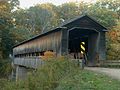 View of bridge - Southeast side
 View of Northwest approach


_Covered_Bridge_2.jpg)
_Covered_Bridge_3.jpg)

_-_panoramio.jpg)

