Montague Harbour Marine Provincial Park
From Wikipedia, the free encyclopedia
| Montague Harbour Marine Provincial Park | |
|---|---|
 Panoramic view | |
 | |
 Interactive map of Montague Harbour Marine Provincial Park | |
| Location | British Columbia, Canada |
| Nearest city | Duncan |
| Coordinates | 48°54′02″N 123°24′18″W / 48.90056°N 123.40500°W / 48.90056; -123.40500 |
| Area | 1.02 km2 (0.39 sq mi) |
| Established | March 6, 1959 (1959-03-06) |
| Governing body | BC Parks |
| Website | bcparks |
Montague Harbour Marine Provincial Park is a provincial park in British Columbia, Canada, located on Galiano Island, one of the Gulf Islands off BC's South Coast in Canada. It is accessible by BC Ferries from Swartz Bay on Vancouver Island or Tsawwassen on the Mainland. The Island's ferry terminal is at Sturdies Bay, about 6 km (3.7 mi) from Montague.
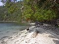
It is a very popular anchorage in the summer months and mooring buoys are provided by the park for visiting boats. It is also a popular spot for kayakers to stop for a night. The park has great camping with sites overlooking the water, picnic tables and pit toilets. It is on a peninsula with beaches and rock pools to play in and explore. There is a small marina within walking distance from the park which stocks basic supplies.
Gallery
 Arbutus menziesii, giant specimen, Montague Harbour Marine Provincial Marine Park
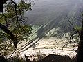 Looking down into reef, Montague Harbour Provincial Marine Park
 Montague Harbour Provincial Marine Park, tidal lagoon with view of Mt. Sutil
 Memorial for Victims of the "Cap Rouge II" Shipwreck at Montague Park
 Sunset, Montague Harbour Marine Provincial Marine Park
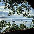


References
This British Columbia protected areas related article is a stub. You can help Wikipedia by adding missing information. |