Nadine, New Mexico
From Wikipedia, the free encyclopedia
Nadine, New Mexico | |
|---|---|
 Nadine  Nadine | |
| Coordinates: 32°37′23″N 103°06′28″W / 32.62306°N 103.10778°W[1] | |
| Country | United States |
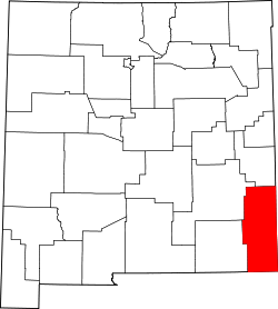
| State | New Mexico |
| County | Lea |
| Area | |
• Total | 11.40 sq mi (29.52 km2) |
| • Land | 11.39 sq mi (29.51 km2) |
| • Water | 0.0039 sq mi (0.01 km2) |
| Elevation | 3,583 ft (1,092 m) |
| Population | |
• Total | 477 |
| • Density | 41.9/sq mi (16.17/km2) |
| Time zone | UTC-7 (Mountain (MST)) |
| • Summer (DST) | UTC-6 (MDT) |
| Area code | 575 |
| GNIS feature ID | 2584159[1] |
Nadine is an unincorporated community and census-designated place in Lea County, New Mexico, United States. As of the 2020 census, Nadine had a population of 477.[4] New Mexico State Road 18 passes through the community.
According to the U.S. Census Bureau, the community has an area of 11.4 square miles (29.4 km2), of which 0.004 square miles (0.01 km2), or 0.05%, are water.[5]