Napanee, Mississippi
From Wikipedia, the free encyclopedia
Napanee, Mississippi | |
|---|---|
  Napanee, Mississippi  Napanee, Mississippi | |
| Coordinates: 33°30′22″N 90°52′15″W / 33.50611°N 90.87083°W | |
| Country | United States |
| State | Mississippi |
| County | Washington |
| Elevation | 121 ft (37 m) |
| Time zone | UTC-6 (Central (CST)) |
| • Summer (DST) | UTC-5 (CDT) |
| GNIS feature ID | 692096[1] |
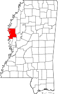
Napanee is an unincorporated community in northern Washington County, in the U.S. state of Mississippi.[1]
The community is located along Clear Creek just west of that stream's confluence with Bogue Phalia. A large fish farm lies just north of the location. Helm, on U.S. 61, lies two miles to the east.[2]