National Highway 46 (India, old numbering)
From Wikipedia, the free encyclopedia
Length148 km (92 mi)
WestendKrishnagiri, Tamil Nadu
EastendWalajapet, Vellore district, Tamil Nadu
CountryIndia
 | ||||
|---|---|---|---|---|
 Map of Old NH46 in red | ||||
 Old NH 46 near Vellore | ||||
| Route information | ||||
| Length | 148 km (92 mi) | |||
| Major junctions | ||||
| West end | Krishnagiri, Tamil Nadu | |||
| East end | Walajapet, Vellore district, Tamil Nadu | |||
| Location | ||||
| Country | India | |||
| States | Tamil Nadu: 148 km (92 mi) | |||
| Primary destinations | Vaniyambadi - Ambur - Vellore - Arcot | |||
| Highway system | ||||
| ||||
National Highway 46 was a national highway in the Indian state of Tamil Nadu. It ran from Krishnagiri to Walajapet in the state.[1] It passed through Vellore and it was a highly important connecting road for vehicles travelling between Chennai and Bangalore. The total Length of NH 46 was 148 km (92 mi). The Krishnagiri-Walajapet section is being upgraded to six lanes by L&T on a build-operate-transfer basis.[2]
Old national highway 46 has been renumbered as National Highway 48, which runs from Delhi to Chennai via Mumbai and Bangalore.[3]
Route
Krishnagiri, Bargur, Nattrampalli, Vaniyambadi, Ambur, Pallikonda, Vellore, Arcot, Ranipet and Walajapet.[4]
Gallery
 NH 46
NH 46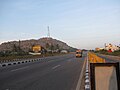 NH 46 near Krishnagiri
 NH 46
NH 46 Vaniyambadi-Toll-Plaza on NH46
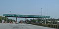 Pallikonda Toll-Plaza on NH46
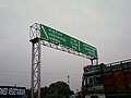 Sign board on NH 46 between Chennai and Vellore.
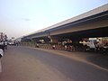 Green Circle Junction flyover on NH 46 in Vellore city
 NationalHighway46India


