Oberaurach
From Wikipedia, the free encyclopedia
Oberaurach | |
|---|---|
 Tretzendorf Castle, today the town hall of Oberaurach | |
 Coat of arms | |
Location of Oberaurach
within Haßberge district 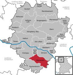 | |
 | |
| Location of Oberaurach | |
 Oberaurach  Oberaurach | |
| Coordinates: 49°55′N 10°37′E / 49.917°N 10.617°E | |
| Country | Germany |
| State | Bavaria |
| Admin. region | Unterfranken |
| District | Haßberge |
| Subdivisions | 11 Ortsteile |
| Government | |
| • Mayor (2020–26) | Thomas Sechser[1] (CSU) |
| Area | |
• Total | 45.14 km2 (17.43 sq mi) |
| Elevation | 350 m (1,150 ft) |
| Population (2023-12-31)[2] | |
• Total | 4,046 |
| • Density | 89.63/km2 (232.1/sq mi) |
| Time zone | UTC+01:00 (CET) |
| • Summer (DST) | UTC+02:00 (CEST) |
| Postal codes | 97514 |
| Dialling codes | 09529 |
| Vehicle registration | HAS |
| Website | www.oberaurach.de |
Oberaurach is a municipality in the district of Haßberge in Bavaria in Germany.
There are 11 quarters belonging to Oberaurach:[3]
- Dankenfeld
- Fatschenbrunn
- Kirchaich and Nützelsbach
- Neuschleichach
- Oberschleichach
- Tretzendorf
- Trossenfurt and Hummelmarter
- Unterschleichach
